Home Tags Posts tagged with "yosemite national park"
yosemite national park
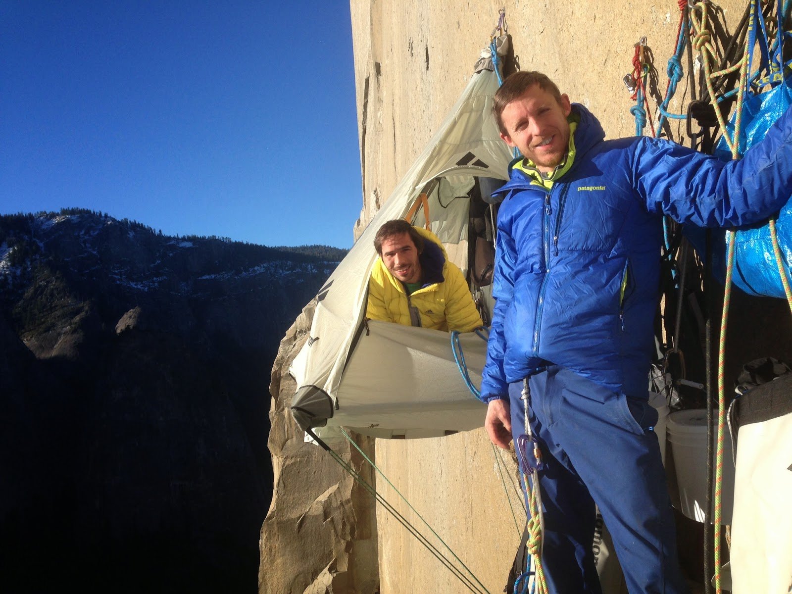
American climbers Kevin Jorgeson and Tommy Caldwell, who spent 19 days clinging to the Dawn Wall of the El Capitan rock formation in California, say they hope their achievement will inspire others.
Tommy Caldwell and Kevin Jorgeson became the first free climbers to scale the sheer Dawn Wall of the El Capitan peak in Yosemite National Park.
They are the first climbers to do so without the usual aids, relying sometimes on fingertip grips.
Kevin Jorgeson said it should show people the importance of teamwork and persistence.
He said the experience “recalibrates your perception of what you can do and what’s possible. Now that we’ve done this, who knows what comes.”
His fellow record-breaker Tommy Caldwell told the New York Times: “I would love for this to open people’s minds to what an amazing sport this is.”
Both men said they had been touched by the number of people who had been inspired by their achievement.
The task began on December 27 and while scaling the 3,000ft rock, they had even climbed in darkness, when sweat was less of an issue.
They took rest days to wait for their finger cuts and grazes to heal and used tape and even superglue to speed up the process.
Tommy Caldwell said support climbers had provided them with fresh fruit and vegetables every five days, plus they had burritos, chocolate and even coffee.
In spare moments, Tommy Caldwell said, he read the autobiography of legendary climber Barry Blanchard.
Kevin Jorgeson said the Dawn Wall “personifies dreaming big and making it happen”.
He added: “It’s just a super-concrete example and an iconic, beautiful place with amazing images and a great story of perseverance and teamwork and making it.”
[youtube l_lZc7nATT4 650]
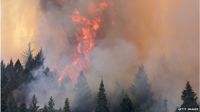
A huge wildfire has burned into California’s Yosemite National Park, park officials say.
The week-old Rim Fire grew to 164 sq miles by Friday morning, and had burned 17 sq miles at the edge of the park by the afternoon.
The blaze has forced scores of tourists to flee during peak season and is threatening thousands of homes.
More than 2,000 firefighters have been tackling the flames in difficult terrain. It is just 2% contained.
California Governor Jerry Brown has declared a state of emergency.
The blaze has reached Yosemite’s backcountry at Lake Eleanor, which is accessible by hiking trails, park spokeswoman Kari Cobb told the Associated Press.
“It’s not a very visited part of the park, even though it is very beautiful,” she said, adding the fire was some 20 miles away from Yosemite’s main tourist area.
Kari Cobb said the park service was “not anywhere near” to closing the attraction.
Yosemite Park blaze has forced scores of tourists to flee during peak season and is threatening thousands of homes
The blaze has shut a stretch of motorway that is one of three entrances to the west side of the park, which receives up to 15,000 visitors a day in the summer.
The Rim Fire is one of 50 major wildfires burning in the western US.
The blaze is centred on Stanislaus National Forest, west of Yosemite, and has so far destroyed two homes and seven outbuildings.
A spokeswoman for the US Forest Service said 4,500 homes, hotels, businesses and several campsites are under threat as of Friday, up from 2,500 the day before.
Officials have gone door to door in the summer community of Pine Mountain Lake urging people to leave.
Local residents said the area, normally teeming with tourists, is now empty.
“This fire, it’s killing our financial picture,” restaurant owner Corinna Loh told the Associated Press.
“This is our high season and it has gone to nothing. We’re really hurting.”
Lee Bentley of the US Forest Service told CBS News: “We’ve got a monster on our hands. This fire is making its own weather.
“It’s going every which direction. This is one of the worst I’ve ever been on. I’ve been doing it for quite a few years.”
The area’s steep hills and rugged terrain are hampering firefighters’ efforts, officials say.
Despite the blaze’s proximity to Yosemite, spokesman Scott Gediman says the park is clear of smoke, and all accommodation and attractions are open.
Meanwhile, five wildfires in Yellowstone National Park have scorched about 18 square miles of mostly remote areas.
[youtube W8OuAsJw8Bs]
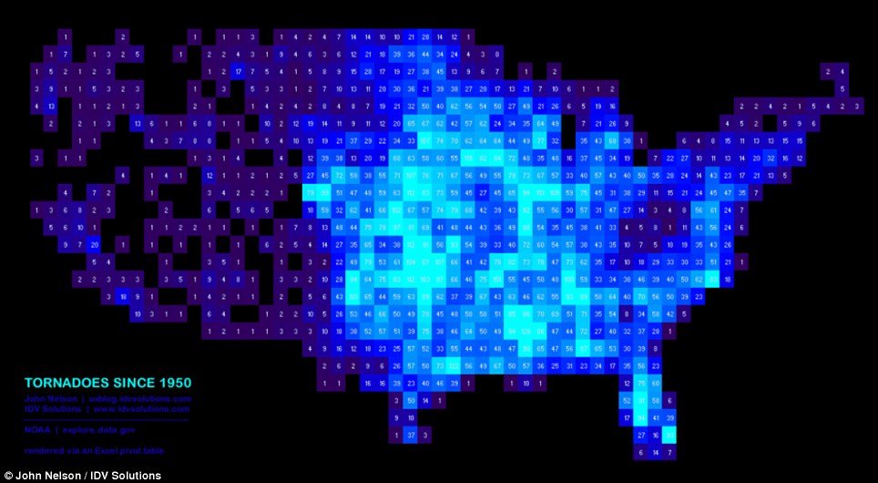
A series of maps have been published illustrating the most deadly places in America.
The data may look spectacular laid out in colorful graphics, but they clearly identify the deadly effects of Mother Nature.
The maps were created by John Nelson, a UX & Mapping manager at IDV Solutions and were reported by the Business Insider.
Using a spreadsheet he converted the data into a pixelated map of the U.S which created the spectacular graphics.
After plotting the data John Nelson was able to create charts which show the most disaster-prone areas across America.
A spectacular blue graphic shows a history of hurricanes across the U.S. since 1851.
Another blue map shows earthquakes across American since 1968, clearly showing which regions are more susceptible to movement.
75 per cent of all tornadoes on Earth occur in the U.S. and John Nelson used the data to construct a vivid electric blue map of tornadoes.

Most dangerous places to live in America
He detailed where they had occurred since 1950 – the most recent was the terrifying tornado was devastated parts of Oklahoma and killed 22 people.
A bright orange map details wildfires across the contagious U.S. since 2001. This month the US forest service chief says hotter, drier conditions mean wildfire season lasts two months longer than it did 40 years ago.
Rain is currently helping firefighters douse Colorado’s most destructive wildfire in state history, while a new wind-whipped blaze in California is forcing evacuations and threatened homes near Yosemite National Park.
The release of the maps come as U.S. mayors pledged this week to make their communities more resilient to increasingly severe floods, droughts, extreme storms and wildfires, which they said was more efficient and cost-effective than disaster clean-up afterwards.
Four dozen elected officials, from localities as diverse as Washington D.C., Des Moines, Iowa and Santa Barbara County, California, released a one-page plan which laid out actions such as using more renewable energy and making buildings and infrastructure more energy-efficient.
The Resilient Communities for America Agreement was launched less than a week after New York Mayor Michael Bloomberg announced a $20 billion plan to prepare his city for rising sea levels and hotter summers.
The actions by local officials took place as anticipation builds that the White House is planning a series of executive actions in July to address climate.
Federal action can help, but local officials are at the front lines of natural disasters, said Des Moines Mayor Frank Cownie. Iowa’s biggest city saw severe flooding in 2008, a trio of ‘500-year’ floods in 2010, a drought in 2012 and the wettest year in 140 years of record-keeping so far in 2013.
“These extreme events are becoming more and more prevalent, and local government is really where it happens,” Frank Cownie said.
He said Federal Emergency Management Agency (FEMA) personnel sometimes are not on the scene until days after disaster strikes, when local officials have already gone ahead with recovery efforts without waiting for federal approval.
“When they show up, it’s good; they’ve got those T-shirts on with FEMA on the back, but they’re just taking notes … We need decision-makers in the throes of an event and we need them immediately,” Frank Cownie said.
El Paso Mayor John Cook said his desert city has been bombarded by wild weather since he took office: Three years’ worth of rain arrived in one week in 2006, causing some $450 million in damage, while in 2011, El Paso’s normally warm weather snapped cold, with temperatures below those of Anchorage, Alaska, for five days, straining local gas lines.
El Paso has spent $100 million to make its buildings more efficient, installing solar panels on library roofs and improving mass transit, with buses that run on compressed natural gas, to cut down on fossil-fueled vehicle traffic.
“The state of Texas should hang their head in shame,” John Cook said.
“They don’t have realistic goal-setting to use renewable energy.”
Nature photographers wait at Yosemite National Park until the moment when the sun and earth align to create a fleeting phenomenon, the firefall.
This marvel of celestial configuration happens in a flash at sunset in mid-February – if the winter weather cooperates.
On those days the setting sun illuminates one of the park’s lesser-known waterfalls so precisely that it resembles molten lava as it flows over the sheer granite face of the imposing El Capitan.
Every year growing numbers of photographers converge on the park, their necks craned toward the ephemeral Horsetail Fall, hoping the sky will be clear so they can duplicate the spectacle first recorded in color in 1973 by the late renowned outdoors photographer Galen Rowell.
“Horsetail is so uniquely situated that I don’t know of any other waterfall on earth that gets that kind of light,” said Michael Frye, who wrote the book “The Photographer’s Guide to Yosemite”.
“How many are perched on a high open cliff? Most are in an alcove or canyon and won’t get the sun setting behind it. Yosemite’s special geography makes this fall distinctive,” Michael Frye said.
Four decades ago, photographers had only to point and shoot to capture another famous Yosemite firefall – a man-made cascade of embers pushed from a bonfire on summer nights from Glacier Point.

In late February, the Horsetail Fall in Yosemite National Park is lit by the sunlight near dusk and displays a rich color like fire
But photographing Horsetail is a lesson in astronomy, physics and geometry as hopefuls consider the azimuth degrees and minutes of the earth’s orbit relative to the sun to determine the optimal day to experience it.
They are looking for the lowest angle of light that will paint Horsetail the colors of an iridescent sunset as rays reflect off granite behind the water. It materializes in varying degrees of intensity for the same two weeks every year.
“If you hit it at just the right time, it turns this amazing color of gold or red-orange,” said Michael Frye, a photo instructor with the Ansel Adams Gallery in the park.
Ansel Adams photographed the fall, but his iconic black and white images do not capture its fiery quality, and it’s unclear whether he ever noted it.
To be successful in photographing the watery firefall, it takes luck and timing, and the cooperation of nature. Horsetail Fall drains a small area on the eastern summit of El Capitan and flows only in the winter and spring in years with adequate rain and snow, which is scarce this year. Experts say it doesn’t take a lot of water for the fall to light up.
Most important, the southwestern horizon must be clear, and February is the time of year when storm clouds often obscure the setting sun.
When conditions come together, the scrawny Horsetail Fall is the shining star of a park famed for its other waterfalls raging Yosemite Fall and Bridalveil Fall. But Horsetail is the longest free-falling one, with a drop of 1,500 feet before it hits granite and spills another 500.
The fire lights up around dusk and lasts for about two minutes. The best views are east of El Capitan along the main roads into and out of Yosemite Valley. Most photographers gather at the El Capitan picnic area, a small pullout marked only by a sign with a table etched on it. But park officials say the inexperienced can look for the hordes of tripods and cameras to find a vantage point.
Recent storms and snowfall mean the finicky fall is flowing again, and park officials are hopeful it will last through February 24, which is generally the last day of the year it can be seen. Once an obscure event, park officials say that Internet discussions have made it more popular in recent years.
The popularity is reminiscent of an actual fiery fall that entertained guests in the park from 1930 to 1968. Each summer evening as the sun set, employees of the park concessionaire would build a huge red fir bark fire atop Glacier Point. At 9 p.m., as the fire burned down to embers and the Indian Love Song waned, someone would yell, “Let the fire fall!”.
With long rakes men pushed glowing coals over the 3,200-foot cliff.
Had visitors looked in the opposite direction at a different time of year they would have seen the watery fire-fall of nature.
“There’s no comparison, and I’ve seen both,” said park spokesman Scott Gediman.
“The natural activities and occurrences in Yosemite are far more amazing and more valuable than the human-made ones – everything from a sunset to wildlife to rainbows at Vernal Fall. There are a lot of amazing things, and they’re here year after year.”
[youtube n1PjugGtteA]
[youtube 9_GawHOBQU0]