NASA has warned that the effects of the current El Nino weather phenomenon could be as bad as those of 1998, the strongest on record.
That El Nino played havoc with world weather systems and was blamed for several extreme weather events.
The current El Nino has been linked to several floods and unusually warm conditions in the northern hemisphere.
The phenomenon sees warm waters of the central Pacific expand eastwards towards North and South America.
El Nino, which occurs every two to seven years, usually peaks late in the calendar year, although the effects can persist well into the following spring and last up to 12 months.
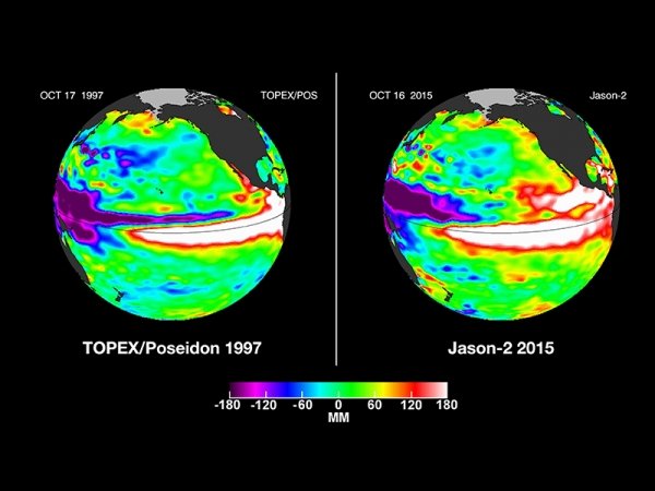
Photo NASA
NASA says the current El Nino “shows no signs of waning”, based on the latest satellite image of the Pacific Ocean.
It bears “a striking resemblance” to one from December 1997, NASA says, “the signature of a big and powerful El Nino”.
This year’s El Nino has been linked to the worst floods seen in 50 years in Paraguay, Argentina, Uruguay and Brazil.
The floods there have forced more than 150,000 people from their homes.
More than 100,000 of those have been in the Paraguayan capital Asuncion alone.
In the US, 13 people have died in Missouri as a result of flooded rivers after tornadoes and storms hit the region.
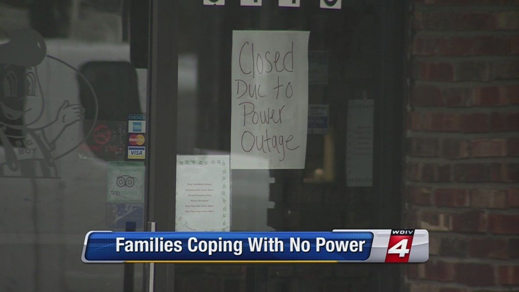
El Nino has also been cited as a factor in the floods that have hit northern parts of the UK, forcing thousands from their homes and leaving thousands more without power.
Storm Frank, which is expected to bring fresh rain and flooding to the UK this week, is part of a weather system which could see temperatures at the North Pole 50F higher than normal for this time of year.
Higher temperatures than the seasonal average have been noted in many parts of Europe and the US.
Average temperatures on Christmas Day in France were the second highest on record, just below those of 1997.
The mild weather has forced farmers to harvest crops such as salad, strawberries and asparagus early, with reports of large amounts of produce going to waste.
In Italy, experts say the unusually calm and dry weather has exacerbated pollution over the cities of Milan and Rome.
By contrast, in Mexico El Nino is being blamed for freezing temperatures in the north of the country, with snow seen in parts of the Sonoran desert for the first time in 33 years. Three deaths have been blamed on the cold in Sonora.
A severe heat wave that has driven daytime temperatures as high as 118°F (48°C) in parts of India has claimed over 500 lives.
Most deaths have taken place in the southern states of Telangana and Andhra Pradesh, where more than 140 people have died since May 23.
Allahabad in Uttar Pradesh recorded 118°F while temperatures rose to above 111°F in the capital, Delhi.
Authorities have urged people to stay indoors and drink plenty of fluids.
Heat wave conditions have been prevailing in the two worst-affected southern Indian states since mid-April, but most of the deaths have happened in the past week.
The worst-hit state has been Andhra Pradesh where 246 people have died from the high temperatures in the past week. State officials said 62 people died of sunstroke on May 24.
Residents of Nalgonda in newly-formed state of Telangana are used to high temperatures during the summer months.
The Press Trust of India (PTI) news agency said the heat wave had killed 186 people in 10 districts in neighboring Telangana state, with 58 people dying since May 23.
The north-western desert state of Rajasthan has also recorded several deaths due to the heat, the PTI reported, including a woman who collapsed and died on a roadside in Bundi city.
The meteorological department said the sweltering conditions were likely to continue for a few more days.
At least 10 people had died of the heat in the eastern state of West Bengal, reports say.
Non air-conditioned taxis will be taken off the road for five hours during the day in the main city in the state capital, Kolkata, after two drivers died from heat stroke.
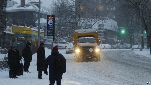
The biggest snowstorm of this season is poised to hit NYC, Boston and Philadelphia over the weekend.
The storm could bring the first widespread heavy snowfall of the winter to the Interstate-95 Northeast corridor, the northern and western suburbs of the I-95 cities and parts of the Appalachians.
Even where moderate snowfall occurs or snow changes to rain, the storm can easily be the biggest snowstorm of the winter so far and bring substantial travel disruptions.
The storm responsible for spreading snow into New Mexico and Texas into Thursday will spread a swath of snow and rain to a large part of the East Friday night and Saturday.
How much snowfall versus rainfall will depend on the track of what will become a significant coastal storm.
Since the storm is still a couple of days away and the exact track is still somewhat uncertain, a shift in track farther to the east or west by as little as 50 miles could have a huge impact on snowfall accumulation.
People traveling to, from or through the I-81 and I-95 corridors on spanning Friday night into Saturday night should expect major delays due to rain in the South and snow or a wintry mix farther north.
Accumulating snow is most likely to fall from the mountains of western North Carolina, eastern Kentucky and western Virginia to southern and eastern Pennsylvania, northern New Jersey, the lower Hudson Valley of New York state and southeastern and central New England. Enough snow is likely to fall to shovel and plow in this area.
Included in the potential swath of accumulating snow is the Interstate-95 corridor from Washington, D.C., and Baltimore to Philadelphia, New York City and Boston. Even though rain could mix in over all or part of this zone, roads will be slippery during much of the storm. Airline delays are likely with the potential for cancellations.
Motorists should expect difficult travel in the I-81 swath from Virginia to Pennsylvania due to slippery and snow-covered roads.
How quickly the storm strengthens will determine how nasty the weather gets in New England. A full-fledged nor’easter or blizzard could hit part of New England with blowing and drifting snow, as well as the potential for damaging wind gusts and coastal flooding.
The storm will behave differently than the storm from last Saturday in that in most cases this will be a snow, rain or snow/rain mix, rather than an extended period of freezing rain. Some sleet can be mixed in as the storm transitions to rain in some coastal areas of the mid-Atlantic and New England.
Over much of the southern Atlantic Seaboard and the Piedmont areas of the Carolinas, enough rain can fall to cause urban flooding problems. Where heavy rain follows heavy snow, along part of the mid-Atlantic and southern New England coasts, there can be street and poor drainage area flooding.
Another storm with snow may swing from the Midwest to the coastal Northeast during the first part of next week.
The “catastrophic” winter storm that gridlocked traffic, left flights cancelled, and knocked out power in the East Coast, has pushed into eastern Canada.
As much as 24in was expected to fall in some areas by the end of Friday, blown about by heavy winds from Quebec to Newfoundland.
Authorities closed a 124 mile section of the Trans-Canada Highway in Quebec.
The storm has been blamed for the deaths of more than two dozen people.
In the US, about half a million of people and businesses remained without power in the typically mild southern states on Friday, some for a third day, after the storm destroyed power lines and knocked down trees.
The weather system tapered off as it crawled farther north, but was still strong enough to bring almost 30cm of snow to areas of Quebec and parts of Newfoundland on Friday, with high winds of more than 60 mph.
Other parts of the eastern provinces and Nova Scotia saw heavy rain from the same storm.
In eastern Quebec, several motorways, including the Trans-Canada Highway from Quebec City to Riviere-du-Loup, were partially shut after the snow and high winds dangerously hindered visibility.
The “catastrophic” winter storm that gridlocked traffic, left flights cancelled, and knocked out power in the East Coast, has pushed into eastern Canada
Canadian weather officials have issued a number of winter storm warnings as another unrelated system is expected to bring severe weather to the Atlantic Provinces again on Saturday and Sunday.
The storm struck first on Wednesday in the US South, where it covered trees and power lines with as much as an inch of ice and caused traffic jams across the region.
South Carolina Governor Nikki Haley compared the damage to the aftermath of a hurricane.
One electric co-operative in the state lost 50 poles in the ice storm, compared to 21 in the last cyclone, officials said. Those still in the dark in the US South may wait several more days before electricity is restored.
The storm then moved up the East Coast, dumping heavy snow from North Carolina to Boston over a 24-hour period. Parts of New York state saw as much as 27in.
Washington-area offices of the US federal government were closed on Thursday to spare workers the dangerous commute.
At least 25 deaths have been blamed on the storm.
In the US, road conditions remained treacherous in some areas on Friday. Thirty people were injured, five severely, in a multiple vehicle pile-up near Philadelphia on Friday morning.
Officials said it would take many hours to clear damaged vehicles, including lorries. The crash spawned a traffic jam stretching for 5 miles.
Many schools remained closed in eight states from Virginia to Maine. Almost 1,700 flights were cancelled on Friday, and 6,500 a day earlier.
The foul weather also has delayed tens of thousands of deliveries of Valentine’s Day flowers.
Meanwhile, a sheriff in north-eastern Georgia declared in an apparently tongue-in-cheek Facebook post that the weather had rendered the Oconee County region a “No Valentines [sic] Day Zone”.
Sheriff Scott Berry declared all men in the area were exempt from having to buy chocolate or other gifts for their partners until next Tuesday.
A “catastrophic” winter storm is unleashing a second wave of heavy snowfall on the US Northeast, as hundreds of thousands of people remain without power in the states in its southern wake.
About 550,000 homes and businesses are still in the dark and almost 1,000 Friday flights are cancelled.
The ice storm has been blamed for at least 22 deaths, including that of a pregnant woman struck by a snowplough.
It is the latest miserable weather to pummel the winter-weary eastern US.
Early this month, Washington DC, Detroit, Boston, Chicago, New York and St Louis had recorded two to three times as much snow as normal by this time in the winter season.
This storm system has already dumped as much as 15in of snow in the Washington DC region and 8in around New York City by Thursday.
Up to another foot is forecast in a second snowfall that began on Thursday evening and is expected to continue through Friday morning, with the heaviest precipitation in the US states of Connecticut and Massachusetts.
The National Weather Service predicted the weather would ease by the weekend.
“Heavy snow will continue tonight… but will begin to taper off from south to north through the morning hours on Friday,” the official forecaster said.
The snow-covered streets in the nation’s capital were largely deserted on Thursday, after the federal government closed its Washington-area offices to spare its widely dispersed workforce the trouble and danger of the drive to work.
A second wave of heavy snowfall hits the US Northeast
On Friday, official Washington will start work two hours behind the ordinary schedule, the Office of Personnel Management said.
More than 6,500 US flights were cancelled on Thursday, according to airline-tracking website FlightAware.com. Another 1,000 on Friday’s schedule have already been grounded.
In New York City, Mayor Bill de Blasio was criticized for keeping schools open on Thursday despite the snow piling on the ground.
The head of the city schools teachers union said it was a “mistake” to have students, parents and school staff travelling under such conditions, while a prominent meteorologist and television personality opened a public spat on Twitter with the mayor.
“It’s going to take some kid or kids getting hurt before this goofball policy gets changed,” Al Roker of NBC wrote on Twitter from Sochi, Russia, where he is covering the Winter Olympics. Al Roker has a daughter in the city schools.
Bill de Blasio responded that many parents depended on schools to watch over their children while they work – and noted the city had closed schools only 11 times for snow since 1978.
“We were convinced that kids could get to schools this morning,” he said.
The multi-day storm has been blamed for almost two dozen deaths.
In New York City on Thursday, a pregnant woman was killed after being struck by a snowplough. Her baby was delivered in critical condition via caesarean section.
The storm moved into the north-east on Wednesday night and Thursday morning, leaving in its southern wake a wreckage of snapped tree branches and power lines coated in as much as an inch of ice.
Most of the remaining power cuts are in South Carolina and Georgia, where President Barack Obama declared a disaster, opening the way for federal aid.
Forecasters said it was one of the worst storms to strike Atlanta, the largest city in the South, since 1973.
A second vicious ice storm in as many weeks caused widespread power outages in Southeast leaving more than half a million people in dark.
Georgia was the worst-hit state with almost 230,000 homes and businesses without electricity, according to figures reported by utility companies at 6:45 a.m. ET.
More than 200,000 customers were experiencing outages in South Carolina with 90,000 others suffering in North Carolina. Louisiana and Virginia also had thousands of people left without electricityl.
Almost 500,000 Georgia Power customers alone had been off the grid, but the company had managed to restore more than half of them.
The Southeast was suffering after being hit Wednesday by a huge storm that stretched from Alabama to Massachusetts.
The ice storm caused widespread power outages in Southeast leaving more than half a million people in dark
But during the night, those without power were not the only people suffering: Ice and fallen trees created dangerous driving conditions for crews trying to get people back on the grid, according to the Georgia Department of Transportation.
More than 3,400 flights into and out of U.S. airports were canceled Wednesday and 3,500 more were delayed. By 3:30 a.m. ET Thursday there were already more than 1,600 US cancelations for the day, according to FlightAware.
By early Thursday, the storm had begun its march up the East Coast, according to Kevin Roth, lead meteorologist at The Weather Channel.
In New York, Pennsylvania, and Washington, D.C., it was expected to dump snow at a furious rate of two inches per hour, making tough work for even the most industrious snowplow crews.
The freezing rain had largely stopped in the South but this was due to morph into snow in parts of Georgia and Alabama, Kevin Roth said.
But with temperatures still below freezing, the ice which built up in parts of Georgia and the Carolinas on Wednesday was not expected to budge. And this was continuing to affect the states’ electricity infrastructure.
As much as an inch of ice built up in all these states, bringing down trees and weighing heavy on fragile power lines. The worst-affected areas were north and east Georgia, central and eastern South Carolina, and central and eastern North Carolina.
A massive ice storm is now poised to pummel the US East Coast after wreaking havoc in the South, say forecasters.
More than 350,000 people are reportedly without power and 3,000 US flights have been cancelled due to ice and strong winds.
Nearly empty roadways were reported as many heeded warnings to stay indoors.
More than 350,000 people are reportedly without power and 3,000 US flights have been cancelled due to ice and strong winds
North Carolina and Virginia are bracing for up to 1ft of snow as the storm rolls north.
It is predicted to drop up to 8in of snow in Washington DC and up to 10in in New York overnight.
At least five traffic accident deaths were blamed on ice in Texas and Mississippi.
The National Weather Service said it was an event of “historical proportions”, drawing comparisons with similar weather systems that struck the Atlanta area in 2000 and 1973.
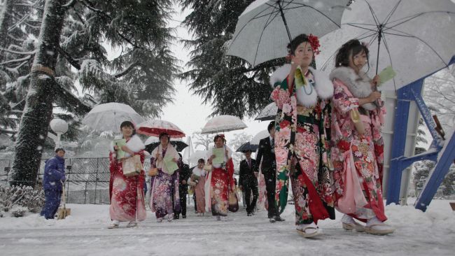
At least 11 people died, more than a thousand were injured and tens of thousands lost power when the worst snowstorm in decades hit Tokyo and areas around the Japanese capital.
Flights were still backed up at Tokyo’s Haneda international airport on Monday and the lobby was packed with anxious travelers, with some flights overbooked.
As much as 10.6 inches of snow fell on Tokyo by late Saturday, the most in 45 years, Japan’s Meteorological Agency said. Back streets in outlying neighborhoods remained choked with snow and frozen slush on Monday morning, forcing commuters in heavy boots to pick their way carefully to work.
Financial markets opened normally on Monday despite the heavy snowfall.
At least 11 people died, more than a thousand were injured and tens of thousands lost power when the worst snowstorm in decades hit Tokyo
Traffic accidents and falls claimed 11 lives across the nation, including one 78-year-old man in Ichikawa, just east of Tokyo. More than 1,000 were injured, among them a 69-year-old man in critical condition after slipping and striking his head at his front doorstep while shoveling snow.
Some 5,000 people were stuck at Narita international airport at the weekend when the snow cut transport links to downtown Tokyo.
More than 20,000 households were without electricity early on Sunday after the snow and high winds took down power lines.
Several universities delayed the start of their entrance exams. The snowy streets also may have discouraged voters from going to the polls on Sunday to choose a new Tokyo governor, with turnout rates hovering around 46%, the third lowest in history.
Japanese authorities warned Tokyo residents to stay indoors as a severe snow storm hit the capital.
Correspondents say it is the first such warning for the city in 13 years.
Hundreds of flights have been cancelled, roads closed and some train services suspended.
Japanese authorities warned Tokyo residents to stay indoors as a severe snow storm hit the capital
Local media has reported that at least 43 people have been injured because of snow-related accidents, with as much as 1.6 in of snow recorded on Saturday morning in Tokyo.
Weather forecasters have warned that with a rapidly developing low pressure front heading towards eastern Japan, more snow can be expected.
Last year parts of northern Japan had as much as 18ft of snow – a record-breaking amount that caused buildings to collapse under its immense weight.
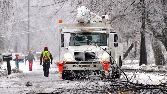
Power supplies and transport have been disrupted after south-west England and south Wales were hit by a powerful storm.
Engineers have been working to restore power but more than 7,000 homes are still without electricity.
In Dawlish, Devon, a section of sea wall under the railway line collapsed, leaving the track suspended in mid-air.
UK’s Prime Minister David Cameron will chair a meeting of the Cobra emergency committee later to consider the government’s response.
It is the first time this year that the prime minister will have chaired a meeting of Cobra to discuss the floods and follows widespread criticism of Environment Secretary Owen Paterson’s handling of the crisis.
Power supplies and transport have been disrupted after south-west England and south Wales were hit by a powerful storm
The prime minister’s office said David Cameron was anxious to ensure that “all that can be done is being done”.
Earlier, First Great Western said all lines between Exeter St Davids and Penzance were closed because of adverse weather conditions and it advised against travel for the rest of the day.
Part of the sea wall at Dawlish, which is between Exeter and Cornwall, has collapsed and the railway station and tracks have been severely damaged by huge waves, driven by gale-force winds.
Western Power Distribution said about 44,000 customers had been affected by power cuts since Tuesday afternoon and 7,400 homes in south-west England remained without power.
The Met Office said gusts of up to 70mph and 20mm of rain had spread from the South West to south-west Wales and eastern Northern Ireland overnight.
Western Power Distribution said there had been high voltage faults due to debris being blown around in Devon and Cornwall.
Teams of engineers worked through the night to try to fix the faults, and the company said it would also switch circuits to work around individual faults.
France and Italy are on flood alert as heavy rain brings chaos to parts of Europe.
Hundreds of people were forced to evacuate their homes in the Italian city of Pisa as the Arno River threatened to burst its banks on Friday.
High seas are expected to cause widespread flooding along France’s Atlantic coast.
Meanwhile, deep snow drifts left dozens of people stranded in Serbia.
Hundreds of people were forced to evacuate their homes in the Italian city of Pisa as the Arno River threatened to burst its banks
Local officials declared a state of emergency and deployed rescue teams to help travelers trapped in their vehicles. Snow storms and strong winds have been sweeping across Eastern Europe.
Italian media said a stretch of medieval wall measuring about 95ft in the town of Volterra, in the province of Pisa, collapsed as a result of heavy rain.
The French department of Finistere, in the west of the country, was placed on red alert as forecasters warned of huge waves and extensive flooding. Ten other French departments were also on alert for rising water levels.
At least two people died and scores had to be airlifted to safety after floods hit south-eastern France earlier this month.
Severe storms have been battering Europe for much of January.
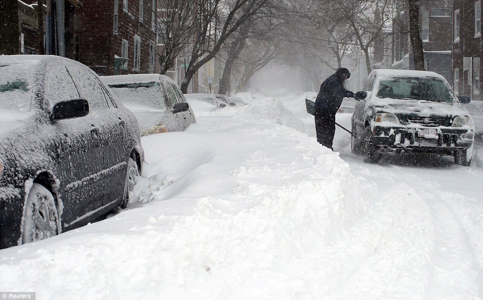
A snow storm spawned traffic chaos in the Deep South leaving thousands of people stranded overnight on motorways, in schools and churches.
Airports and roads were closed as five states declared emergencies.
Military vehicles were deployed to aid stuck motorists and to reach those in need of food and water.
Barely 3in of snow caused havoc in a warm-weather region where many cities do not even have snow ploughs or fleets of salt trucks.
Hundreds of road accidents were reported, a number of them involving trucks jackknifing on highways.
Despite ample weather warnings, school officials waited until the middle of Tuesday when snow was already falling to send students home on routes where traffic was grinding to a halt.
Nearly 8,000 students across Georgia and Alabama spent the night in school gyms or on buses, reports ABC News.
Many commuters abandoned cars along jammed motorways to seek shelter in churches and fire stations.
A snow storm spawned traffic chaos in the Deep South leaving thousands of people stranded overnight on motorways, in schools and churches
Gridlock on the streets of Atlanta, Georgia, was so bad that a police officer had to deliver a baby on a snowy motorway.
Georgia Governor Nathan Deal said on Wednesday morning that the National Guard had sent military Humvees on to the city’s motorways to move stranded school buses and provide food and water to people.
A school bus flipped over as it was driving students home amid dismal weather near Asheville, North Carolina.
Motorists were instructed to stay off roadways in Louisiana, Mississippi, Georgia, North Carolina and South Carolina, where states of emergency were declared.
“Residents should not overreact but should make plans now to ensure they are prepared for prolonged freezing conditions and icy roadways,” Mississippi Governor Phil Bryant told US media.
At least five people were killed due to weather-related accidents in Alabama on Tuesday.
New Orleans’ main airport, which was closed on Tuesday, has reopened with a reduced service.
Some 1,700 flights across the US were grounded on Wednesday.
State legislature activities in South Carolina were also cancelled due to weather.
The latest cold snap stretched across much of the US on Wednesday, sending temperatures as low as -30F.
A second major winter storm will hit the East Coast with up to 12in of snow, blowing wind and bitter cold forecast.
Even before the first flakes had fallen, the government offices in Washington DC and schools in several states were closed pre-emptively.
In New York, snow began falling during the morning commute, and authorities warn of hazardous road conditions.
And more than 2,500 flights have already been cancelled.
The storm comes just two weeks after a weather pattern known as the polar vortex brought heavy snow and record low temperatures to the eastern half of the US.
A second major winter storm will hit the East Coast with up to 12in of snow, blowing wind and bitter cold forecast
Winter storm warnings have been declared from West Virginia to Boston, with some of the heaviest accumulations threatened along the coastal cities.
Washington DC is expected to see its heaviest snow fall in three years, and temperatures across the eastern US are expected to be 10 to 25 degrees colder than average on Tuesday and Wednesday, according to the National Weather Service.
As the snow began falling in Washington DC, the White House cancelled its daily press briefing and a meeting of President Barack Obama’s commission on electoral administration.
The weather has also affected New Jersey Governor Chris Christie’s second inauguration. Organizers have cancelled the party scheduled for Tuesday night on Ellis Island in New York Harbor.
The polar vortex that has left people in North America shivering for days, shattering century-old temperature records, is loosening its icy grip.
Temperatures are rising in the Midwest and East, which has borne the brunt of polar vortex, but are still below freezing in many areas.
At least 21 people have died since Sunday as a result of the weather, and more than 11,000 flights were grounded.
US natural gas usage hit an all-time record in the US to meet heat demands.
Forecasters predicted weather would return to normal across much of the US in the coming days, after 50 US cities set new record low temperatures on Tuesday.
The National Weather Service predicted “a much-anticipated warm up” for much of the eastern US on Wednesday.
The Midwest – which experienced -37C (-35F) in recent days – also warmed slightly, but still faced temperatures 15 to 25 degrees below average.
Atlanta, Georgia, returned to a more temperate 5C (42F) on Wednesday following a record low of -14C (6F) a day earlier.
The polar vortex that has left people in North America shivering for days is loosening its icy grip
New York City topped -5C (22F) on Wednesday, after shattering a 118-year-old low temperature record with -15C (4F) on Tuesday.
Temperatures in parts of North America plunged so low this week that they eclipsed readings recently recorded on the Red Planet by the Mars Rover.
Even Alabama’s top official was not immune to the extreme cold.
Governor Robert Bentley faced an estimated $50,000 in damage after a water pipe froze and burst in the attic of his home in Tuscaloosa.
Guy Walton, a meteorologist at The Weather Channel, told media that the worst of the Arctic outbreak is over.
“It will be getting dramatically warmer from today,” he said on Wednesday.
“By Thursday temperatures will be almost back to normal.”
Scientists also posited a silver lining to the cold snap, saying it could kill some of the pests that have ravaged northern forests.
The low temperatures may also slow the migration of invasive species and prevent erosion of wetlands, they say.
All 50 US states saw freezing temperatures as weather records have tumbled across North America.
The most extreme arctic blasts, blamed on a weather pattern known as the polar vortex, were said to have affected nearly 190 million people.
In Kentucky, an escaped prisoner turned himself in to get out of the cold.
Some parts of the Midwest hit -26C (-14F), as low as the Antarctic coast in winter, and much colder than the inside of a domestic freezer.
Temperature records were shattered in states across the US, including Alabama, Georgia, Tennessee, Arkansas, Michigan, Maryland, Ohio, Pennsylvania and New York.
It was -17C (1F) in the small town of Hell, Michigan, prompting online jokes that the weather was so bad even hell had frozen over.
But it was Embarrass, Minnesota, that experienced the lowest temperature in the nation on Tuesday: -37C (-35F).
That was colder than readings recently recorded on the Red Planet by the Mars Rover.
All 50 US states saw freezing temperatures as weather records have tumbled across North America
A video of a meteorologist tossing a pot of boiling water into the air in Wisconsin, to demonstrate how it immediately turns to snow, quickly went viral on the internet and was widely imitated.
The extreme weather resulted in the usual travel chaos – nearly 2,700 US flights were cancelled on Tuesday.
More than 500 rail passengers on their way to Chicago were marooned overnight into Tuesday morning in northern Illinois on three Amtrak passenger trains after drifting snow and ice covered the tracks.
The big freeze was even testing the resolve of Canadians, no strangers to cold weather.
Temperatures in parts of Ontario fell to -30C (-22F), causing flights in and out of Pearson International Airport to be halted for several hours on Tuesday morning.
Roads in the cities of Toronto and Ottawa were coated in dangerous black ice.
Freezing temperatures were recorded in all 50 US states, including the usually balmy California and Florida.
Even tropical Hawaii experienced -7C (18F), reports the Associated Press news agency, although that was at the peak of Mauna Kea, a dormant volcano.
Atlanta, Georgia, was 25 degrees below average for this time of year.
People in the Midwest are still digging out from two massive snow storms recently which dumped more than 2ft of snow.
A reprieve is expected soon, however, with forecasters predicting temperatures above freezing for much of the US in the coming days.
The Northeast and Upper Midwest are braced for potentially record-breaking low temperatures as a “polar vortex” brings more freezing weather.
A winter storm has already blanketed areas of Canada and the north-eastern US with up to 2ft of snow.
The snow storm has been blamed for 16 deaths in recent days and the cancellation of more than 3,700 flights this weekend.
Schools in Chicago are among those closing as officials tell people to stay indoors on Monday.
Meanwhile, a plane from Toronto slid into snow as it turned onto a taxiway after landing at New York’s JFK airport on Sunday.
No-one was hurt in the incident but all flights at the airport were suspended for two hours because of icy runways.
The plunging temperatures result from the polar vortex, an anti-clockwise pool of cold, dense air.
Forecasters say temperatures in the north and central US could feel as low as -60F (-51C) with the effect of wind chill.
Authorities have warned residents to remain indoors, both for their own safety and to keep roads clear for snow removal.
The Northeast and Upper Midwest are braced for potentially record-breaking low temperatures as a “polar vortex” brings more freezing weather
In Canada, thousands of people on the island of Newfoundland remain without power due to a transformer fire linked to heavy snow.
“The coldest weather in years will be making its presence known from the Upper Midwest to the Mid-Atlantic region for the beginning of the work week,” the US National Weather Service said in a statement.
The states of Ohio, South Dakota and Illinois are among those set to be hit. Tennessee and Kentucky are forecast to see several inches of snow.
The weather service said “an incredibly strong surge of bitterly cold Arctic air” was sweeping across the country until Tuesday.
It is set to continue to the north-east, where residents are still digging out from the week’s deadly snowstorm.
It could bring some of the coldest temperatures in two decades.
In Canada, the temperature dropped as low as -20F (-29C) in Toronto and -36F (-38C) in Quebec City with wind chill on Thursday – the lowest seen in at least two decades there.
Heavy snow has also affected US states including New York, Connecticut and Massachusetts. Boston was said to be the worst hit with nearly 18 in of snow.
Schools have also been closed across the state of Minnesota for Monday, as well as for parts of Wisconsin, Illinois and Indiana, among others.
Officials in Chicago, Illinois reversed a decision to keep schools open following criticism from a teachers’ union, according to the Associated Press.
State offices were to stay closed in neighboring Indiana where a state of emergency was declared in Lake County in the northwest, allowing only emergency or law enforcement vehicles on the roads.
The Green Bay Packers football team handed out hot chocolate and hand warmers to fans at a game being played in Wisconsin on Sunday. Doctors had urged fans to wear at least three layers of clothing.
Sixteen deaths have been blamed on the wide-ranging storm, according to the Associated Press news agency.
The Midwest is bracing for potentially record-breaking low temperatures as an Arctic chill brings more freezing weather.
A winter storm has already blanketed areas of Canada and the north-eastern US with up to 2ft of snow.
It has been blamed for 16 deaths and the cancellation of more than 5,000 flights since Wednesday.
Forecasters say temperatures in the Midwest could feel as low as -58F (-50C) with the effect of wind chill.
Authorities have warned residents to remain indoors, both for their own safety and to keep roads clear for snow removal.
In Canada, tens of thousands of people on the island of Newfoundland remain without power due to a transformer fire linked to heavy snow.
“The coldest weather in years will be making its presence known from the Upper Midwest to the Mid-Atlantic region,” the US National Weather Service said in statement.
The states of Ohio, South Dakota and Illinois are among those set to be hit.
The weather service said “an incredibly strong surge of bitterly cold Arctic air” would sweep across the country from Saturday night until Tuesday.
It is set to continue to the north-east, where residents are still digging out from the week’s deadly snowstorm.
The Midwest is bracing for potentially record-breaking low temperatures as an Arctic chill brings more freezing weather
It could bring some of the coldest temperatures in two decades.
“The last really big Arctic outbreak was 1994,” Reuters news agency quoted Bob Oravec, a forecaster with the National Weather Service, as saying.
“Outbreaks like this don’t occur everyday.”
In Canada, the temperature dropped as low as -29C (-20F) in Toronto and -38C in Quebec City with wind chill on Thursday – the lowest seen in at least two decades there.
Heavy snow has also affected states including New York, Connecticut and Massachusetts, with school closed, transport systems drawn to a halt and residents told to stay at home.
Boston was said to be the worst hit with nearly 18in of snow.
Sixteen deaths have been blamed on the wide-ranging storm, according to the Associated Press news agency.
A salt storage worker was killed in Philadelphia when a 100-ft pile of road salt fell and crushed him. A woman suffering from Alzheimer’s disease in New York state froze to death after she wandered away from her rural home.
Some 1,200 flights were cancelled across the US and about 6,000 flights delayed on Saturday, according to reports. This followed more than 4,000 cancellations earlier in the week.
Chicago’s O’Hare International Airport and Newark Liberty International Airport in New Jersey were said to be among the worst affected.
This weekend will bring a deep freeze that could prove fatal for the ill-equipped across the Midwest.
States such as Illinois, Minnesota and Wisconsin will see lows in the minus teens and minus 20s. And with sub-zero winds whipping through some areas, it could feel more like the minus 50s and minus 60s, meteorologists warn.
The Weather Channel warned that “one of the coldest arctic air masses in nearly 30 years” was likely to hit the Plains and Midwest this weekend. Some all-time cold records appeared to be in jeopardy, forecasters said.
Snow is expected to begin falling throughout the Midwest on Sunday, also reaching parts of Tennessee and Alabama. Along the East Coast, the storm will bring rain but be accompanied by warmer weather.
Minnesota isn’t taking any chances on Monday. Governor Mark Dayton said all public schools will be closed for the day.
Minneapolis will see a high of minus-14 degrees and a low of minus 27 degrees through Monday – but with the wind chill it would feel like the minus 40s.
“The safety of Minnesota’s schoolchildren must be our first priority,” Mark Dayton said in a statement.
One of the coldest arctic air masses in nearly 30 years is likely to hit the Plains and Midwest this weekend
“I have made this decision to protect all our children from the dangerously cold temperatures now forecasted for next Monday. I encourage Minnesotans of all ages to exercise caution in these extreme weather conditions.”
Temperatures won’t be any better in Chicago, which will come close to a high of minus 11 degrees – a record mark previously reached in December 1983 and January 1994.
Perhaps the most foolhardy will be football fans in Wisconsin. Sunday’s NFC wild-card game between the Green Bay Packers and the San Francisco 49ers will play out in bone-chilling minus-5-degree temperatures.
Meanwhile, cities across the mid-Atlantic to the Northeast will see milder temperatures with rain Sunday into Monday. New York City will see highs in the lower 40s. Boston, digging out from as much as two feet of snow, could reach 50 degrees.
While airports in the areas hardest hit by Friday’s big storm still grappled with some residual flight problems, less than 800 into or out of the U.S. had been canceled as of 11 a.m. ET Saturday, according to FlightAware. More than 2,600 flights into or out of the U.S. were canceled by midday Friday.
New York’s John F. Kennedy International Airport, which reported 192 cancelled flights due to “zero visibility and high winds” at midday Friday, cut that number to 37 on Saturday morning. The trend carried to other area airports; La Guardia only reported 25 canceled flights on Saturday as compared with Friday’s 271, and Newark slashed its numbers from 285 to 37.
Boston’s Logan International Airport reported 23 cancellations Saturday morning and most other U.S. airports reported cancellations in the teens or single digits.
While the next wave of northeast weather might not affect air travel, another frigid plunge is forecast for Tuesday: New York City is expected to see a high of around 10 degrees, while Philadelphia and Boston will be in the teens.
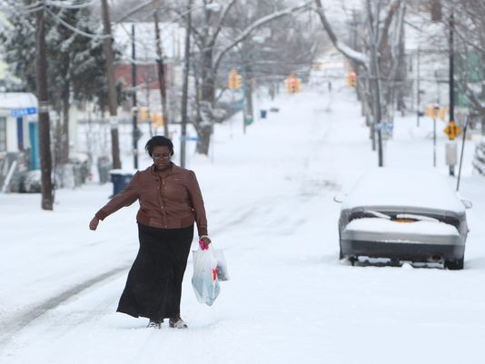
A massive winter storm has blanketed the Northeast with up to 2 ft snow and ushered in dangerously cold temperatures Friday, leaving travelers stranded and a cutting a deadly path across several states.
The storm has been blamed for 11 deaths and forced the cancellation of more than 4,000 flights since Wednesday.
Authorities warned residents to remain indoors, both for their own safety and to keep roads clear for snow removal.
Fatal traffic accidents occurred in New York, Michigan, Kentucky, Indiana and Illinois. Authorities said a woman suffering from Alzheimer’s disease froze to death after she wandered away from her rural western New York home.
And in suburban Philadelphia, as the storm approached, a worker at a salt storage facility was killed when a 100-foot-tall pile of road salt fell and crushed him. Falls Township police said the man was trapped while operating a backhoe.
The big storm followed closely the blueprint meteorologists drew up, slamming the Northeast overnight Thursday with as much as two feet of snow and sub-zero wind chills through Friday. The biting wind and blowing snow shut down interstates and airports alike and gave millions of school children a snow day.
John F. Kennedy Airport in New York was officially closed at 6:12 a.m. Friday and reopened four hours later, while Boston’s Logan International was effectively shut down, as well.
Interstate 84 in New York and the Long Island Expressway, closed at midnight as the storm roared in, remained so until 8 a.m.
The Northeast snowstorm has been blamed for 11 deaths and forced the cancellation of more than 4,000 flights since Wednesday
Snowfall reports varied widely, with New York City receiving 7 inches in some areas, Baltimore seeing 3 to 6 inches, Philadelphia closing in on 9 inches, Hartford 6 to 10 inches and Boston as much as 15 inches.
Some 20 inches fell on other parts of Massachusetts. Boxford, northwest of Boston, reported 23 inches.
The brutal storm blasted at least 22 states – stretching from Chicago through the New York tri-state region into New England – and affected an area home to more than 100 million people.
The high temperature in New York City reached the 20s on Friday during the day and was expected to drop to the single digits in the evening, with the wind chill making it feel well below zero.
“It’s deceptively cold outside. If you stay outside too long it could be dangerous,” New York City’s new mayor, Bill de Blasio, said at a news conference Friday morning, while hundreds of plows and salt spreaders continued to clear the roads.
Temperatures from upstate New York to Maine were below zero, and wind chills — the “feels like” effect — were minus-30 in some spots.
Across the Northeast, residents were fretting about the blast of bitter cold.
The weather was affecting air travel, with more than 2,600 flights cancelled Friday and another 8,800 delayed, according to flight tracking website FlightAware.
The delays and cancellations in storm-socked parts of the country created a logjam in other areas, including causing flights in Los Angeles to be delayed or scrapped Friday.
A major snowstorm and blizzard-like conditions are expected to affect 100 million people across the Midwest and Northeast.
While the immediate focus was on snow – with up to 10 inches possible in New York City, possibly 18 inches burying New England, and more than 1,800 flights canceled – the cold behind the snowstorm could be crippling.
The high temperature in New York City will be in the teens on Friday during the day and drop to between 5 and 8 degrees in the evening, with the wind chill making it feel well below zero. Lows in Boston will be below zero. Maine could see the mercury drop to minus 30 after dark.
“That is a very, very dangerous set of circumstances,” Massachusetts Gov. Deval Patrick said. He dismissed all state workers at 3 p.m. and urged residents to minimize time outside and be aware of frostbite and hypothermia symptoms.
A second wave of icy weather will hit the nation’s midsection by late Sunday, stretching from the upper Midwest to Kentucky and Tennessee, forecasters said.
Chicago will struggle to get above minus 8 and by Monday morning the wind will make it feel like it’s 40 below zero there.
Blizzard targets Northeast after pounding Midwest
In Green Bay, Wisconsin, where the Packers host an NFL playoff game Sunday evening, the low temperature could reach minus 18.
Larry Wittmers, a hypothermia expert at the University of Minnesota-Duluth medical school, said it’s not necessarily the coldest areas that face the most peril.
“True hypothermia cases turn up more often in more southern regions because people are not prepared and don’t know what to do,” Larry Wittmers said.
How long people can safely spend outside depends on how wet or windy it is and how they are dressed, he said. Shoveling snow or other exercise can be dangerous because sweat reduces the insulation capability of clothing, and consuming alcohol can speed heat loss and reduce awareness of the cold.
And even though record snowfall is not expected, the cold could make roads even more hazardous because the snow-melting homeowners and road crews use loses effectiveness at between 10 and 20 degrees.
Winter storm warnings and advisories were in effect in 22 states, stretched from Chicago through the New York tri-state region into New England and affecting an area home to more than 90 million people.
Flights were being canceled by the hundred at some of the nation’s busiest airports. Five hundred had been scrapped at Newark, LaGuardia and Kennedy; Boston’s last departure was slated for 8:30 p.m.; almost 600 were off the boards at Chicago’s O’Hare, according to FlightAware.
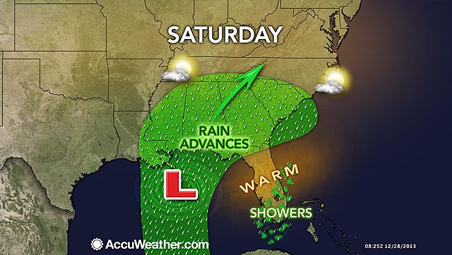
A storm will hit the South during Saturday night and much of the mid-Atlantic and southern New England on Sunday bringing a dose of drenching rain, minor flooding and travel delays.
Those taking to the roadways should expect poor visibility from the driving rain and be wary of water collecting on portions of the highway that drain poorly.
The rain will be heavy enough to cause flash, urban and small stream flooding. However, fast movement of the storm system will prevent widespread and major flooding of larger streams and rivers. A general 1 to 2 inches, with locally 3 inches of rain is forecast and should be handled with few problems on the major rivers.
Downpours, fog and low cloud ceilings can lead to flight delays.
The storm was already spreading rain across the Gulf Coast on Saturday morning. It was a wet drive along the I-10 corridor from much of Louisiana to Mississippi and Alabama.
Atlanta can expect rain on Saturday afternoon through Saturday night, but improving travel conditions on Sunday.
The storm will hit the South during Saturday night and much of the mid-Atlantic and southern New England on Sunday
Farther northeast along the I-85 corridor, rain will soak the Charlotte and Raleigh, N.C., areas on Saturday night into Sunday morning. Expect a miserable drive Saturday night along I-77 with rain, but also fog over the high ground.
The rain will reach Richmond and Roanoke, Virginia, late on Saturday night.
In the I-95 swath from Jacksonville, Florida to Savannah, Georgia, along the coasts of South and North Carolina, to southeastern Virginia, thunderstorms will also affect some locations with strong, gusty winds and blinding downpours
A couple of the strongest storms can produce a short-lived tornado.
On Sunday, rain and thunderstorms will push southeastward across the Florida Peninsula, while clearing sweeps from west to east across the interior South.
Farther north along I-95 from Washington, D.C., to Philadelphia and New York City on Sunday, rain will spread northward. A breeze will cause the rain to be windswept at times, further reducing the visibility and adding misery to those attending NFL games.
The rain will reach across southern New England on Sunday afternoon and evening from Hartford, Connecticut, and Providence, Rhode Island, to Boston.
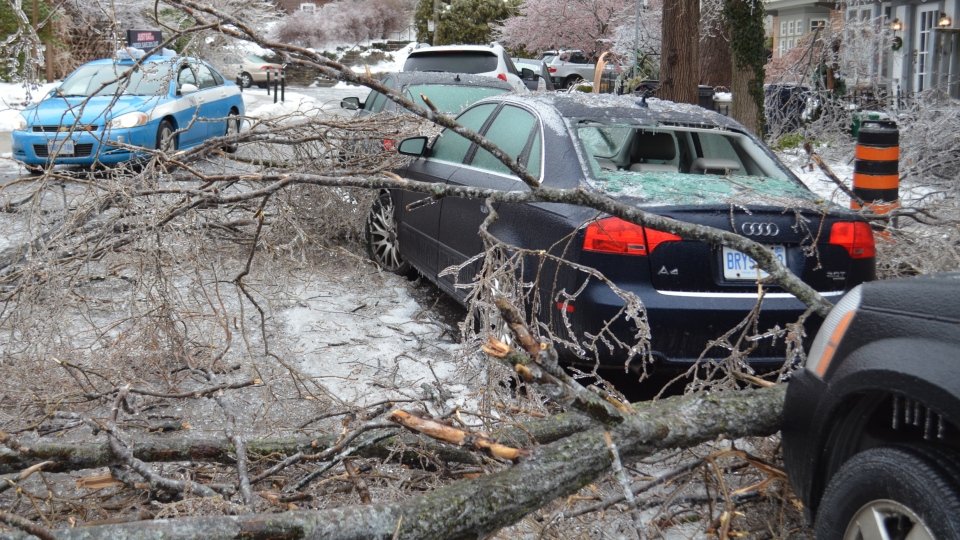
More than half a million households in the north-eastern US and the south-eastern Canada are still without electricity after last weekend’s severe ice storm.
Utility crews are working round-the-clock, but warn that some homes could be without power at least until Saturday.
In Toronto, 72,000 people were without electricity on Christmas Day, officials in Canada’s Ontario province said.
At least 27 deaths in the region have been linked to the storm.
Most of those were caused by apparent carbon monoxide poisoning as people used gas generators, charcoal stoves and other appliances to heat their homes in freezing temperatures.
In Toronto, 72,000 people were without electricity on Christmas Day
“I understand they want to keep warm, but you cannot do this. This is deadly,” Toronto Mayor Rob Ford warned earlier this week.
Other fatalities were caused by traffic accidents.
Elsewhere in Canada, tens of thousands of people are still without power in New Brunswick and Quebec, and hundreds in Nova Scotia.
In the US, states from Maine to Michigan have been affected by the adverse weather.
Travel between Toronto and Montreal, Ottawa and New York had been disrupted.
Environment Canada meteorologist David Phillips warned earlier this week that the ice would remain as temperatures stayed below freezing.
More than 200,000 homes and businesses remained without electric power for a fourth day in parts of Michigan and Maine.
Utility crews worked through the Christmas Day to try to restore electricity cut off by a severe ice storm Sunday.
The worst affected state was Michigan, with about 158,000 customers remained without power at 2 p.m. ET on Christmas Day, utilities companies said.
More than 59,000 customers in Maine continue to lack power. Crews were putting the final patches on power lines in Vermont and New York state, where outages were in the thousands earlier this week.
More than 200,000 homes and businesses remained without electric power for a fourth day in parts of Michigan and Maine
With temperatures far below freezing, ice on power lines was refusing to budge after the severe weekend weather.
Most of the hotels and motels around Flint, Michigan, had no vacancies Tuesday night as families poured in from hard-hit towns to be somewhere warm for the holiday.
In Maine, emergency officials across the state said the ice storm had created the worst conditions since the Great Ice Storm of January 1998, which left some parts of New England without power for months.
In Waldo County, more than 30,000 customers were without power Tuesday night — equivalent to about three-quarters of the county’s entire population.
More than 300,000 homes and businesses in Michigan, upstate New York and northern New England remained without electricity Monday morning after thick ice felled trees and brought down power lines, according to utilities companies.
Brad Hoving, a meteorologist with the National Weather Service in Grand Rapids, Michigan – the state with a bulk of the remaining power outages — said many people may still be using candlelight until Thursday.
The Red Cross set up a shelter at Middleville, Michigan, United Methodist Church, but Pastor Tony Shumaker said the crowd was getting too big and needed additional accommodations like showers, so they would be moving to a local school. Church members planned to cook a Christmas dinner and bring it to the school for people who were still without power on Wednesday.
More than 300,000 homes and businesses in Midwest and northern New England remained without electricity following a major ice storm
Tony Shumaker said regardless of the inconvenient timing of lost power, the people housed at the church “seem to be in pretty decent spirits, they’re glad to have a warm place to go to”.
One of Michigan’s power providers, DTE, said crews were working “around the clock” and 90% of the 83,000 customers without electric would be restored by Christmas Eve. However, Consumers Energy said over 200,000 customers were in the dark, and many areas in the southwest portion of Michigan would not be fully restored until after the holiday.
Michigan was hit with half an inch of ice over the weekend.
The storm also saw some 1,200 US flights canceled over the weekend and delayed another 15,000, according to the aviation-tracking website FlightAware.
At least 14 deaths across the US and Canada were blamed on the storm, the AP reported.
Nine of these fatalities came in the US, including five people killed in Kentucky and a woman in Arkansas following a 130-mph tornado.
AAA predicted that a record-breaking 94.5 million Americans will travel 50 miles or more between December 21st and January 1st.
The worst weather will focus on the days prior to Christmas as millions of travelers take to the roads and skies in the US and southern Canada.
According to AAA, 94.5 million people will travel 50 miles or more over the holiday season, spanning December 21st to January 1st.
Most of the travel troubles will be caused by a single storm system forecast to affect much of the Central and Eastern states on Saturday and Sunday.
The storm this weekend will bring a wide variety of weather ranging from temperature extremes to heavy snow, ice, flooding rain, fog, severe thunderstorms and the potential for tornadoes. Major airport hubs from Dallas to St. Louis, Detroit, Atlanta, Chicago, Boston and New York City.
Another dose of snow will sweep inland over the Northwest to the northern Rockies on Monday.
The main storm this weekend will begin to put down snow across the northern Texas Panhandle and western Oklahoma on Saturday.
The worst weather will focus on the days prior to Christmas as millions of travelers take to the roads and skies in the US and southern Canada
As the storm rolls out, heavy snow will develop later Saturday over central Kansas and will continue along a northeasterly path Saturday night and Sunday through northwestern Missouri, central and southeastern Iowa and Wisconsin, much of northern Michigan and across central Ontario, southern Quebec and northern New Brunswick.
Portions of the central Plains, Upper Midwest and southeastern Canada could be on the receiving end of a foot (30 cm) of snow. Ice and a wintry mix is also another concern for travelers with the storm from part of central Oklahoma to southern Michigan, southern Ontario, along the St. Lawrence River in Ontario, northern upstate New York, northern New England central and southern New Brunswick. Enough ice can accumulate in part of this area to bring down trees and power lines.
The snow and ice could bring vehicles to a crawl or possibly shut down portions of I-29, I-35, I-70, I-80 and I-90 in the US, and highways 2, 20, 40 and 401 in Canada.
On the southeastern flank of the storm from central and coastal Texas to southern New England, drenching rain will fall. Some of the rain will be heavy enough to cause flooding.
Episodes of dense fog could also be a player in slowing ground travel and causing flight delays, especially from around the Great Lakes to the Northeast.
Farther south, there is the risk of damaging thunderstorms and tornadoes from parts of central Texas to the southern tip of Indiana Saturday and Saturday night, with the risk of locally severe thunderstorms farther east on Sunday.
A cold front associated with the storm system will push showers and thunderstorms to the Atlantic Seaboard late in the weekend. Downpours, poor visibility and locally gusty winds could cause travel delays during this time from Boston to New York City, Philadelphia, Washington, D.C., Charlotte and Atlanta Sunday afternoon and evening.
Until then, much of the area will bask in record-challenging warmth. Prior to downpours late in the weekend, fog could be a problem for a time from Philadelphia to New York City and Boston Saturday. Gusty winds could be an issue at some airports in the Northeast on Sunday.
This website has updated its privacy policy in compliance with EU GDPR 2016/679. Please read this to review the updates about which personal data we collect on our site. By continuing to use this site, you are agreeing to our updated policy. AcceptRejectRead More
Privacy & Cookies Policy
Privacy Overview
This website uses cookies to improve your experience while you navigate through the website. Out of these, the cookies that are categorized as necessary are stored on your browser as they are essential for the working of basic functionalities of the website. We also use third-party cookies that help us analyze and understand how you use this website. These cookies will be stored in your browser only with your consent. You also have the option to opt-out of these cookies. But opting out of some of these cookies may affect your browsing experience.
Necessary cookies are absolutely essential for the website to function properly. This category only includes cookies that ensures basic functionalities and security features of the website. These cookies do not store any personal information.
Any cookies that may not be particularly necessary for the website to function and is used specifically to collect user personal data via analytics, ads, other embedded contents are termed as non-necessary cookies. It is mandatory to procure user consent prior to running these cookies on your website.