Home Tags Posts tagged with "Meteorology"
Meteorology
2014 is in the running to be the warmest year globally since records began, early estimates show.
In the first 10 months of 2014, global average air temperature was about 0.57 Celsius above the long-term average.
The global figures come in estimates from the UN’s World Meteorological Organization (WMO).
If this year’s current global trend continues for the next two months, the previous record years of 1998, 2005 and 2010 will be overtaken by a narrow margin.
The Secretary-General of the WMO, Michel Jarraud, said the preliminary data for 2014 was “consistent with what we expect from a changing climate.”
In comments released with the new figures, he said: “The provisional information for 2014 means that fourteen of the fifteen warmest years on record have all occurred in the 21st century.”
Michel Jarraud highlighted the impacts of the weather extremes.
“Record-breaking heat combined with torrential rainfall and floods destroyed livelihoods and ruined lives. What is particularly unusual and alarming this year are the high temperatures of vast areas of the ocean surface, including in the northern hemisphere.”
He asserted that the new figures confirm the key trend in climate change: “There is no standstill in global warming.”
This is a reference to the hotly-debated “pause” in global warming which has seen no major increases in temperature since 1998.
The provisional record for 2014 is only slightly higher than for the previous record year of 2010 – one-hundredth of a degree – which was 0.56C above the long0-term average.
However, climate scientists point out that all but one of the warmest 15 years have come in this century.
This suggests that although there have been no big jumps in temperature in the past 16 years, the period as a whole is proving to be exceptionally warm.
The waters of the eastern Pacific are among those to have warmed significantly – a situation which might normally be expected to trigger so-called El Nino conditions that often boost global warmth. However, puzzlingly for scientists, these have yet to materialize.
If 2014 does prove to set a new record for global average temperatures, it will have been without the warming contribution of an El Nino.
The WMO figures say that although “one warm year does not necessarily say anything about long-term climate change” new research shows how human influence made record temperatures more likely.
The WMO report on the state of the global climate is published every year to coincide with the UN’s annual negotiations on climate change, this time under way in Lima in Peru.
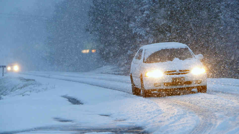
A massive ice storm is now poised to pummel the US East Coast after wreaking havoc in the South, say forecasters.
More than 350,000 people are reportedly without power and 3,000 US flights have been cancelled due to ice and strong winds.
Nearly empty roadways were reported as many heeded warnings to stay indoors.

More than 350,000 people are reportedly without power and 3,000 US flights have been cancelled due to ice and strong winds
North Carolina and Virginia are bracing for up to 1ft of snow as the storm rolls north.
It is predicted to drop up to 8in of snow in Washington DC and up to 10in in New York overnight.
At least five traffic accident deaths were blamed on ice in Texas and Mississippi.
The National Weather Service said it was an event of “historical proportions”, drawing comparisons with similar weather systems that struck the Atlanta area in 2000 and 1973.
[youtube 41xQEpdey7s 650]
At least 11 people died, more than a thousand were injured and tens of thousands lost power when the worst snowstorm in decades hit Tokyo and areas around the Japanese capital.
Flights were still backed up at Tokyo’s Haneda international airport on Monday and the lobby was packed with anxious travelers, with some flights overbooked.
As much as 10.6 inches of snow fell on Tokyo by late Saturday, the most in 45 years, Japan’s Meteorological Agency said. Back streets in outlying neighborhoods remained choked with snow and frozen slush on Monday morning, forcing commuters in heavy boots to pick their way carefully to work.
Financial markets opened normally on Monday despite the heavy snowfall.

At least 11 people died, more than a thousand were injured and tens of thousands lost power when the worst snowstorm in decades hit Tokyo
Traffic accidents and falls claimed 11 lives across the nation, including one 78-year-old man in Ichikawa, just east of Tokyo. More than 1,000 were injured, among them a 69-year-old man in critical condition after slipping and striking his head at his front doorstep while shoveling snow.
Some 5,000 people were stuck at Narita international airport at the weekend when the snow cut transport links to downtown Tokyo.
More than 20,000 households were without electricity early on Sunday after the snow and high winds took down power lines.
Several universities delayed the start of their entrance exams. The snowy streets also may have discouraged voters from going to the polls on Sunday to choose a new Tokyo governor, with turnout rates hovering around 46%, the third lowest in history.
[youtube 5cB5m7MUDNE 650]
A snow storm spawned traffic chaos in the Deep South leaving thousands of people stranded overnight on motorways, in schools and churches.
Airports and roads were closed as five states declared emergencies.
Military vehicles were deployed to aid stuck motorists and to reach those in need of food and water.
Barely 3in of snow caused havoc in a warm-weather region where many cities do not even have snow ploughs or fleets of salt trucks.
Hundreds of road accidents were reported, a number of them involving trucks jackknifing on highways.
Despite ample weather warnings, school officials waited until the middle of Tuesday when snow was already falling to send students home on routes where traffic was grinding to a halt.
Nearly 8,000 students across Georgia and Alabama spent the night in school gyms or on buses, reports ABC News.
Many commuters abandoned cars along jammed motorways to seek shelter in churches and fire stations.

A snow storm spawned traffic chaos in the Deep South leaving thousands of people stranded overnight on motorways, in schools and churches
Gridlock on the streets of Atlanta, Georgia, was so bad that a police officer had to deliver a baby on a snowy motorway.
Georgia Governor Nathan Deal said on Wednesday morning that the National Guard had sent military Humvees on to the city’s motorways to move stranded school buses and provide food and water to people.
A school bus flipped over as it was driving students home amid dismal weather near Asheville, North Carolina.
Motorists were instructed to stay off roadways in Louisiana, Mississippi, Georgia, North Carolina and South Carolina, where states of emergency were declared.
“Residents should not overreact but should make plans now to ensure they are prepared for prolonged freezing conditions and icy roadways,” Mississippi Governor Phil Bryant told US media.
At least five people were killed due to weather-related accidents in Alabama on Tuesday.
New Orleans’ main airport, which was closed on Tuesday, has reopened with a reduced service.
Some 1,700 flights across the US were grounded on Wednesday.
State legislature activities in South Carolina were also cancelled due to weather.
The latest cold snap stretched across much of the US on Wednesday, sending temperatures as low as -30F.
[youtube i5ywebF1xo8 650]
According to forecasters, Deep South will be hit by what could be its worst snow and ice in a generation.
Schools were closed, hundreds of flights were scrapped and cities blew the dust off the few snowplows they have Tuesday.
From Texas to the Carolinas, almost 40 million people are in the storm’s path.
In New Bern, North Carolina, where the last 6-inch snowfall happened in 1989, forecasters said as much as 7 inches could come down. In Charleston, South Carolina, and Savannah, Georgia, ice was the major threat – as much as a half-inch.
Columbia, South Carolina, a city of 130,000 people with only eight snowplows, was expecting up to 4 inches of snow. The city put emergency workers on 12-hour shifts and mixed up sand, salt and brine to put on the city’s major roadways as the weather got worse.
Schools were closed from Texas through the Florida Panhandle and up to North Carolina. The Johnson Space Center in Houston shut down for the day. Mississippi Gov. Phil Bryant declared a state of emergency for almost half the state’s counties.

Deep South will be hit by what could be its worst snow and ice in a generation
Drivers were warned to use extreme caution or stay home entirely. Just north of Austin, Texas, where ice was accumulating on bridges and overpasses, emergency crews responded to a reported 20-car wreck.
Airlines canceled more than 2,600 flights, including more than 800 in the hub of Atlanta and more than 600 at the major airport in Houston.
Snow was already falling Tuesday morning from just north of Austin, Texas, up to the southern tip of Maryland, and a band of ice reached from San Antonio to the suburbs south of Atlanta.
By Wednesday, forecasters said, the storm will bend up the East Coast, traveling as far north as Providence, Rhode Island, before moving offshore by lunch.
Farther north, millions of people suffered Tuesday under another day of deep freeze. Subzero temperatures stretched from Montana to Pennsylvania. It was 11 below zero as the sun came up in Chicago, 8 below in Pittsburgh and 6 below in Cincinnati.
The unbearable cold forced schools to close in Minnesota, Chicago and western Pennsylvania. The University of Michigan shut down because of weather for the first time since 1978. Lake Geneva, Wis., recorded its 17th day of subzero temperatures this winter, double the average.
The latest blast of frigid weather arrived just as a shortage of propane, the fuel used by 14 million Americans to heat their homes, reached critical proportion.
With prices more than doubling from $2 a gallon to more than $4 last week, the governors of Minnesota and Illinois declared states of emergency Monday, urging people to cut back and regulators to lift restrictions on shipping to their states.
[youtube xez5TgqN1zM 650]
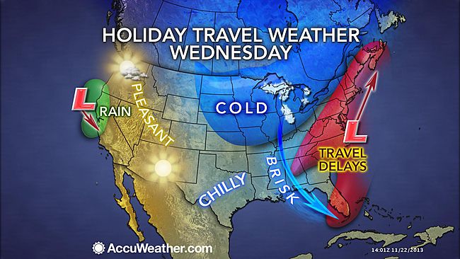
Thanksgiving travelers in the East and South on Tuesday and Wednesday will face trouble as a storm brings most areas rain but could also bring heavy snow to a narrow swath.
However, much of the rest of the nation will be dry.
The same storm affecting the Southwest with snow, ice, rain and thunderstorms this weekend will reach the Southeast with rain Tuesday. From there the storm will turn up the East Coast, tracking into colder air, perhaps causing even greater travel disruptions.
AccuWeather.com COO Evan Myers said: “If the storm hugs the coast and develops to its full potential, it could be a flight nightmare, not only for travelers in the East, but also throughout the nation.”
After drenching coastal Texas on Monday, the storm will cruise eastward along the Gulf coast Monday night and Tuesday.
Travel delays on the I-10 and I-20 corridors are in store from Louisiana to Mississippi, Alabama, Georgia and northern Florida from rain-soaked highways and poor visibility from downpours.
The rain can be heavy enough and cloud ceilings low enough to delay flights at New Orleans, Atlanta and other airports in the region.

Thanksgiving travelers in the East and South on Tuesday and Wednesday will face trouble as a storm brings most areas rain but could also bring heavy snow to a narrow swath
During Tuesday night, the drenching rain will begin to swing northeastward across South and North Carolina to Virginia, along the I-95 and I-85 corridors.
Right along the Gulf coast and over part of the southern Atlantic Seaboard, there is also the potential for strong to locally severe thunderstorms.
The exact track and intensity of the storm as it swings up or slips off the East Coast Tuesday night into Wednesday night are still in question and hold the key to dry weather versus rain versus snow in some locations.
Even if rain were to fall over much of the area, it would be enough to slow travel on the highways and delay a number of flights. Gusty winds would also factor in to delays along the coast, even if the storm were to roll out to sea.
Rain is the most likely form of precipitation from Virginia to near New York City then southeastern New England, with the air simply being too warm or the warm waters of the Atlantic Ocean exerting its influence. This includes Richmond, Virginia, Washington, D.C., Baltimore and Philadelphia.
If fresh cold air invades the storm, then there could be a period of snow over the mountains from northern West Virginia and western Maryland to central and northeastern Pennsylvania, upstate New York and western and northern New England. If this scenario pans out, major travel disruptions could be in store for portions of I-80, I-81, I-87, I-90 and I-91.
Only if the storm were to strengthen a great deal and draw more cold air in would there be a change from rain to snow in New York City, Hartford, Connecticut, and Boston.
For those traveling on Thanksgiving Day, the storm or its near-miss will likely have exited much of the region. However, some rain or snow is still possible early in the day in northern New England.
More details on the track of the storm and forecast for the Northeast will be released on AccuWeather.com as they becomes available.
A storm is forecast to move in from the Pacific Ocean during the middle of the week.
This storm will has a chance of bringing rain to the I-5 corridor in California to part of Oregon Wednesday into Thanksgiving Day.
As a result, there is a chance of wet weather and perhaps travel delays from San Francisco to Los Angeles. Some snow is possible in the Sierra Nevada and over Donner Pass along I-80.
Much of the rest of the nation will have good travel conditions.
Beware, aircraft and flight crews originating from the South and Northeast could be delayed, perhaps causing ripple-effect problems with a few flights throughout the nation.
There will be bands of lake-effect snow over the Upper Midwest, due to fresh cold air moving in Tuesday and Wednesday. The lake-effect snow should diminish in most locations by Thanksgiving Day.
[youtube -lRIQOOPvRI 650]
Around 140,000 homes are without power as St Jude storm continues to batter parts of England and Wales.
According to specialists, St Jude storm could be one of the worst storms since 1987.
Rail services across much of southern Britain have been cancelled for the morning rush hour.
The M4 Second Severn crossing has reopened but the M48 Severn Bridge is still closed, while 130 flights have been cancelled at Heathrow airport.
The Met Office said a gust of 99mph was recorded at Needles Old Battery, Isle of Wight, at 05:00 GMT.
The Environment Agency has issued 17 flood warnings – all in south-west England, there are also 152 flood alerts across England and Wales.

According to specialists, St Jude storm could be one of the worst storms since 1987
Tracy Elsey, from UK Power Networks, said 40,000 households were without power in its south-east region from Brighton to Kent – and 100,000 in its east of England region, from Essex to the north Norfolk coast.
“The power lines are hit by trees coming down in the wind and branches touching overhead lines and any other debris whipped up by the wind overnight,” she said.
Robin Gisby, network operations managing director for Network Rail, said more than 40 railway line blockages caused by falling trees have been cleared, but more are expected to be found by special trains being used to clear tracks.
He said: “In four cases the train being sent through to inspect the line has hit a fallen tree and we have one train in Devon which is currently disabled following a collision with a fallen tree. We are also dealing with a landslip in the New Forest area.”
Robin Gisby added: “As the storm passes from west to east, we will be carrying out safety assessments as quickly as possible to clear routes and get trains running safely.
“We now expect to start services into Waterloo before 09.00 GMT. Routes from Sussex, Kent and Anglia will follow. Services elsewhere into London are running but at reduced capacity and speed.”
[youtube Y0oaidQa7z4 650]