Shah Kamal, Bangladesh’s disaster management secretary, told AFP that the
evacuated residents had been moved to more than 5,500 cyclone shelters.
Mamata Banerjee, Chief Minister for the Indian state of West Bengal, tweeted
before the cyclone made landfall urging people to stay calm.
She wrote: “Please do not panic.
“Kindly remain calm and
co-operate with the administration in its rescue and relief efforts. Be alert,
take care and stay safe.”
Forecasters expect Cyclone Bulbul to move north and weaken gradually.
According to the Bangladesh Meteorological Department, the cyclone is set to
reach wind speeds of up to 75mph, with gusts of 94mph, and create tidal surges
in the sea and rivers when it hits the coastal regions.
Along Bulbul’s predicted path is the Sundarbans, the world’s largest
mangrove forest and home to the endangered Bengal tigers.
Indian authorities said military ships and planes have been put on standby
to assist with emergencies.
Bangladesh’s low-lying coast is often hit by deadly cyclones, but it has successfully reduced the number of casualties in recent years.
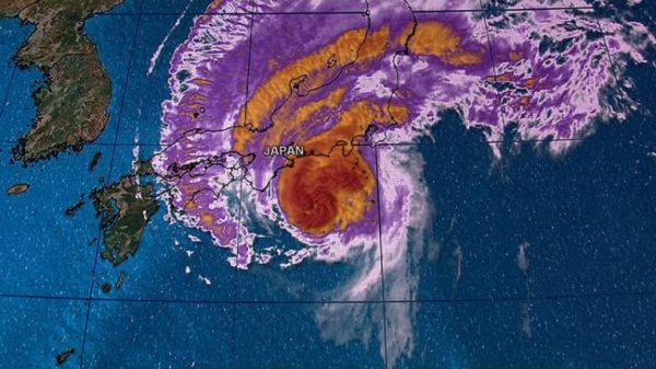
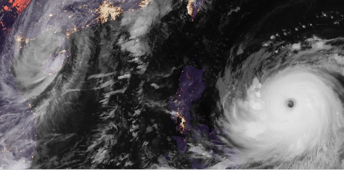
Japan has been hit by Typhoon
Hagibis, the worst storm for 60 years.
The eye of Typhoon Hagibis made
landfall on the country’s main island shortly before 19:00 local time, in Izu
Peninsula, south-west of Tokyo.
The typhoon is now moving up the
eastern coast, with wind speeds of 140mph.
One man was killed in Chiba, east of
Tokyo, when his car overturned, and at least 60 people have been injured.
More than seven million people have
been urged to leave their homes amid severe flood and landslide warnings, as torrential
rain and tornado-like winds are lashing large parts of the country.
However, it’s thought only 50,000 are staying
in shelters.
Train services have been halted, and
more than a thousand flights grounded. Thousands of homes lost power in and
around the capital earlier on Saturday, though some were swiftly reconnected.
Two Rugby World Cup games scheduled
for October 12 have been canceled and declared as draws – England-France and
New Zealand-Italy. Formula 1 has also canceled qualifying races for October 12
Japanese Grand Prix.
Japan’s Meteorological Agency (JMA)
has warned that half a metre of rain could fall on the Tokyo area between midday
on October 12 and 13.
JMA forecaster Yasushi Kajiwara told
a press briefing: “Unprecedented
heavy rain has been seen in cities, towns and villages for which the emergency
warning was issued.
“The possibility is extremely high that disasters such
as landslides and floods have already occurred. It is important to take action
that can help save your lives.”
Hagibis, which means
“speed” in the Philippine language Tagalog, is forecast to hit the
main Japanese island of Honshu.
Typhoon Hagibis could be the strongest
storm Japan has faced since Typhoon Vera in 1959, which hit Japan with winds of
190mph and left more than 5,000 people dead or missing.
Locals stocked up on provisions before Hagibis’ arrival on the authorities’ advice, leaving supermarkets with empty shelves.
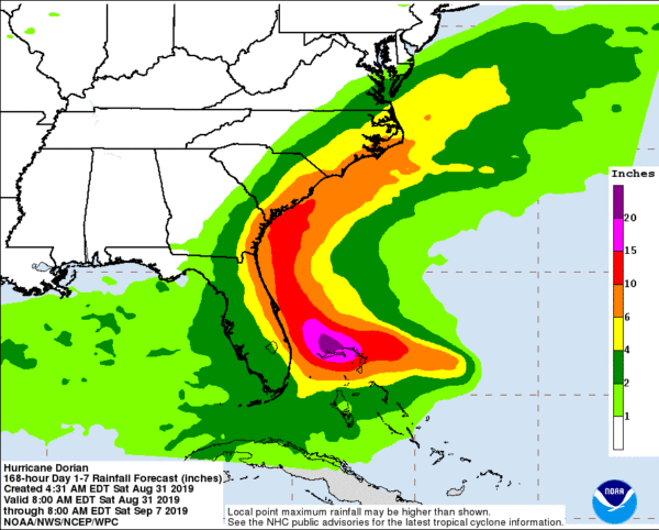
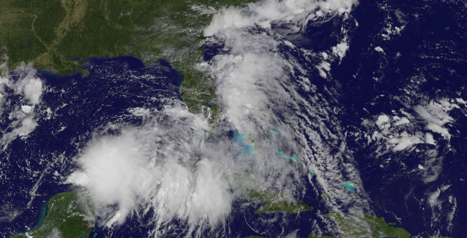
Hurricane Dorian threatening the Bahamas and the
US south-eastern coast has strengthened to category four, the US National
Hurricane Center (NHC) says.
Dorian has maximum sustained winds of nearly 145mph.
The hurricane is expected to grow even stronger, its center potentially
crossing the Bahamas before skirting Florida’s east coast early next week.
Reports from the Bahamas described tourists scrambling to leave before the
closure of the international airport.
In Florida, Governor Ron DeSantis has declared state of emergency for the
whole state and urged residents to stock enough food, water and medicine to
last at least a week.
According to forecasters, Dorian could be the region’s worst storm since
category five Hurricane Andrew killed 65 people and destroyed 63,000 homes in
1992.
President Donald Trump said he was monitoring Dorian, which he described as
“an extremely dangerous storm” on Twitter.
Hurricanes, whose strength can range
from category 1 to 5 on the Saffir-Simpson scale, tend to get stronger as they
move over warm waters like those off Florida.
By the middle of next week,
forecasters expect the hurricane to shift eastwards, putting the coasts of
Georgia and South Carolina at risk.
“Dorian is anticipated to remain an extremely dangerous
major hurricane while it moves near the north-western Bahamas and approaches
the Florida peninsula into early next week,” the NHC said.
The NHC warned that Dorian could cause “incredibly catastrophic
damage”.
In an advisory on August 31, the NHC said Dorian was not expected to make
landfall in Florida but the possibility that it will cannot be ruled out.
“Life-threatening storm surge and
devastating hurricane-force winds are still possible along portions of the
Florida east coast by the early to middle part of next week,” the NHC
said.
Residents of Georgia and South Carolina have been told to keep an eye on the
forecast as Dorian churns towards the US coast.
Dorian’s exact path toward Florida remains uncertain but millions of people
could be affected, as well as holiday attractions such as Walt Disney World and
President Donald Trump’s Mar-a-Lago resort.
Dorian is expected to drop up to 12in of rain on the coastal US, with some
areas getting as much as 18in. Tides in the region are already at some of their
highest levels of the year, owing to a naturally occurring event.
A new moon, combined with the coming autumn equinox, has created what are
known in Florida as “king tides”. These are likely to exacerbate
dangerous levels of flooding, forecasters warn.
Florida governor has activated 2,500 National Guard troops, with another
1,500 on standby.
Shoppers in Florida have been queuing around the block to snap up supplies
such as medication and fuel. Some petrol stations reported fuel shortages,
while a few shops had run out of bottled water.
The coastal city of Miami ordered the removal of electric rental scooters
from the streets to avoid any potential hazards.
Officials fear the rental scooters, operated by firms such as Lime, Lyft and
Uber’s Jump, could be swept away by strong winds, turning them into
projectiles.
No immediate mass evacuations have been ordered by state authorities but
President Trump, who had warned that Dorian “could be an absolute
monster”, said a decision could be made on Sunday.
People have been asked to bring their pets with them in case of evacuation.
On social media, the names of hotels that accept pets are being shared.
Orlando International Airport announced it was halting commercial flights
from 02:00 on September 2 “out of an abundance of caution”. Tourist
resorts in the city remained open, however.
President Trump canceled a planned trip to Poland because of the storm, sending Vice-President Mike Pence instead.
A red alert has been declared in China as powerful
typhoon Lekima heads towards the eastern coast.
Typhoon Lekima is currently battering Taiwan with winds of more than 120mph
and is due to make landfall in China’s Zhejiang province on August 10.
Emergency teams have been deployed to the region to guide relief work,
China’s emergency ministry said.
Thousands of people further up the coast in Shanghai have been warned to
prepare to evacuate.
Lekima, which is the ninth typhoon so far this year, strengthened into a
super typhoon late on August 7, but Taiwanese authorities have since downgraded
it to a regular typhoon.
Flood warnings have been issued for eastern sections of China’s Yangtze
River and the Yellow River until August 7. The provinces of Jiangsu and
Shandong are also on alert.
Cruise liners have been told to delay their arrival in Shanghai and some train
services have been suspended over the weekend.
China has also canceled some trains heading to and from the Yangtze delta
region.
Lekima is one of two typhoons in the western Pacific at the moment. Further
east, Typhoon Krosa is spreading heavy rain across the Northern Mariana Islands
and Guam. According to forecaster, it is moving north-west and could strike
Japan sometime next week.
On August 9, Lekima was passing the north of Taiwan, causing flight cancelations
and the closures of schools and offices.
According to local media, power was cut to more than 40,000 homes and the
island’s high speed rail service was suspended north of the city of Taichung
The huge storm came a day after eastern Taiwan was rattled by a 6.0
magnitude earthquake. Experts said the risks of landslides triggered by the
tremor were made more likely by the typhoon dumping up to 35 inches of rain on
Taiwan’s northern mountains.
On August 9, Lekima also brought heavy rain and high winds to south-west
Japan, cutting power to about 14,000 homes, broadcaster NHK reported.
China’s weather bureau said typhoon Lekima was expected to have weakened further by the time it made landfall. The country has a four-stage color-coded warning system, with red representing the most severe weather.
The US East Coast is shivering in a record-breaking freeze in the wake of a deadly “bomb cyclone” that dumped snow as far south as Florida.
In parts of US and Canada, temperatures were forecast to fall below -20F, with wind chill making it feel more like -90F on January 5.
In Canada, high winds have knocked out power for tens of thousands of residents in Nova Scotia.
Thousands of snow ploughs are clearing roads across the East Coast.
On January 5, the National Weather Service (NWS) predicted dangerously low temperatures moving into the weekend as frigid air lingering over the North Pole prowls towards the US mid-Atlantic region.
In Massachusetts, residents of Boston, which received over 1ft of snowfall, were clearing the streets with shovels.
It comes just days after a phenomenon described as a “bomb cyclone” brought heavy snowfall to a wide area along the East Coast, as well as hurricane-force winds.
Giant waves caused by the storm saw freezing floodwaters inundate parts of the New England coast.
According to reports, the extreme weather has so far been linked to up to 19 deaths in the US and two more in Canada.
Four deaths were reported in traffic accidents in North and South Carolina. Further fatalities occurred in Wisconsin, Kentucky and Texas.
In Philadelphia, a car was unable to stop at a railway line at the bottom of a steep hill and was hit by a commuter train, killing a passenger in the vehicle.
In Virginia, a girl was fatally struck by a car while sledging, and a 75-year-old man was killed after being hit by a snow plough.
In Perth Amboy, New Jersey, where the temperature averaged 20F on January 4, a 13-year-old girl died and 35 others suffered carbon-monoxide poisoning in an apartment building. Seven of those treated were first responders.
The extreme weather caused travel chaos and led to the cancellation of thousands of flights on January 4 and 5.
Most flights have since resumed at airports in New York and Boston.
Experts say the so-called bomb cyclone storm drew moisture and strength from as far south as the Caribbean Sea.
New Hampshire’s Mount Washington, which boasts of having the “world’s worst weather”, was forecast to experience a wind chill temperature as low as -90F on January 5.
Law enforcement in Indiana issued a joke warrant for the arrest of the heroine in Disney movie Frozen, blaming her for the cold snap.
Most of northern Europe, including France and Germany and the UK, has been battered by winter storm Eleanor leaving tens of thousands of homes without power and affecting transport.
In France, a skier died in the Alps and 15 others were injured elsewhere in the country, four of them seriously.
A train was blown off its tracks in Switzerland, leaving several people with minor injuries. One person was hit by a falling tree in the Netherlands.
Wind gusts may reach 124mph.
In northern France, Eleanor cut power to more than 200,000 households and it is set to move to other regions throughout the day, including Corsica.
Air travel was also disrupted in the capital, Paris, and in the east of the country.
In Paris, the Eiffel Tower was closed because of the strong winds. The French capital’s parks have also been closed until the storm dies down because of worries over falling tree branches.
A skier was killed by a falling tree in Morillon, in the Haute-Savoie region of eastern France.
Image source Flickr
In Germany, the storm – named Burglind there – has swept over much of the country. It packed gusts of more than 75mph in the west of the country and led to transport disruption, reports say.
Switzerland has also been badly hit, with some 14,000 homes without power. The high winds left several people stranded in a ski lift in St Gallen canton, overturned a light airplane in Stans and snapped the 42ft high Christmas tree in the capital Bern, Reuters reports.
Meanwhile, record wind gusts of 122mph were recorded on Pilatus Peak near the Swiss city of Lucerne, broadcaster SRF reported.
Belgium was put on “orange” alert, the third of four warning levels, with officials urging people to be cautious when going out because of tree branches and other flying objects.
In the Netherlands, gusts of more than 68mph were recorded as hundreds of flights were cancelled at Amsterdam’s Schiphol airport.
Several main roads and train lines were also closed.
Dutch authorities have, for the first time, shut all five major sea barriers to prevent flooding, as large areas of the country are below sea level.
In the UK thousands of homes are without power and travel has been disrupted after Storm Eleanor hit there.
Specialists recorded gusts reaching 100mph overnight with a weather yellow warning still in place for Wales, England, most of Northern Ireland and parts of southern Scotland.
In the Republic of Ireland, 97mph gusts were recorded, and there was flooding, travel disruption and damage to buildings.
President Trump has approved a federal aid for the worst-affected areas and praised emergency services in a tweet: “You are doing a great job – the world is watching! Be safe.”
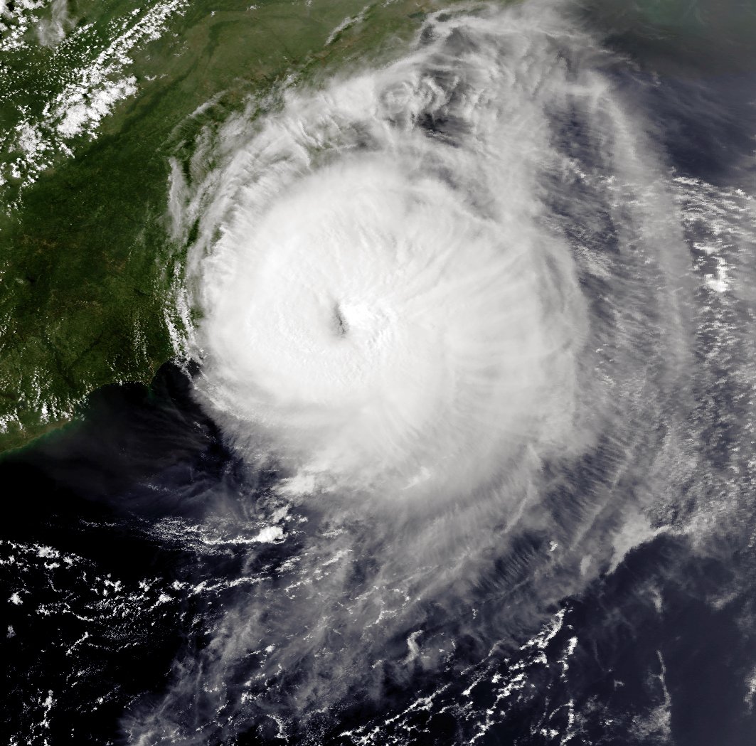
Texas Governor Greg Abbott warned of record flooding in multiple regions after Harvey made a double landfall: north-east of the city of Corpus Christi initially, then just north of Rockport a few hours later.
Rockport, normally home to about 10,000 people, appears to have been the hardest hit. Emergency services there say a number of buildings have suffered structural damage.
Images posted on social media show collapsed trees and houses.
Hurricane Harvey, which may be the worst storm to hit the US mainland in 12 years, is expected to make landfall on Texas’ central coast late on Friday or early Saturday.
The hurricane is currently a category two storm in the Gulf of Mexico.
Harvey may bring 35in of rain, 130mph winds and 12ft storm surges, say forecasters.
At 10:00 AM local time, the eye of Harvey was about 115 miles south-east of the Texas coastal city of Corpus Christi, the National Hurricane Center (NHC) said. It had sustained winds of 110mph.
Harvey – which has been gaining strength – is likely to strike at the heart of Texas’s oil refining industry.
Oil-rich Houston, the fourth biggest city in the US, could face up to 20in of rain over the coming days, officials there said.
Meteorologists are warning of extremely high volumes of rainfall as the storm stalls over the middle Texas coast.
They say Hurricane Harvey could remain in the area, dumping rain until the middle of next week.
On top of that, the central Texas coast is likely to see a significant storm surge – this happens when low pressure at sea “lifts” tides to a level higher than normal, up to 12ft in this case, and high winds then blow the water in land.
Image source Wikimedia
The NHC said it expected “catastrophic flooding” across the coast and in some inland areas throughout south-east Texas.
Energy companies have been evacuating staff from offshore platforms in the Gulf of Mexico.
Texan oil refineries on land are also shutting down in preparation for the storm. As a result, US fuel prices have reached a three-week high.
Joe McComb, mayor of Corpus Christi, a coastal city of more than 300,000 people, urged householders to take the warnings seriously and evacuate low-lying areas.
“I hope people will listen to forecasters when they say <<beware of flash floods>>,” he said.
“Flash floods can come quickly, and they can be deadly.”
According to the NHC, the wind speed is currently almost 110mph, though gusts are even stronger.
On August 25, the NWS said it expected Harvey to make landfall as a Category Three hurricane, out of a maximum of five.
If it does, Harvey will be the strongest to hit the US since October 2005, when Hurricane Wilma struck the coast of Florida.
Hurricane Wilma left 87 people dead, and was part of a record-breaking hurricane season that included Katrina, which devastated New Orleans and killed nearly 2,000 people in August of that year.
New Zealand’s authorities have ordered evacuations in towns along the north coast, where severe weather warnings are in place ahead of Cyclone Cook.
Heavy rain has begun to hit the North Island, ahead of what is being called the worst storm in generations.
Cyclone Cook is due to make landfall from 19:00 local time over Bay of Plenty. Officials have warned of high waves, storm surges and landslides.
It is then expected to move to the South Island early on April 14.
Cyclone Cook comes after severe floods caused by the remnants of Cyclone Debbie hit some parts of New Zealand last week.
The storm – expected to bring torrential rain and winds gusting at up to 93mph – has been classified as an extra-tropical cyclone.
Image source Wikimedia
According to the New Zealand MetService, that means it has changed into a different kind of weather system on approach to New Zealand, but has not necessarily weakened or been downgraded.
Parts of New Zealand’s North Island are now under a state of emergency, with residents in the low-lying parts of Coromandel, which has already seen landslips and closed roads, being told to leave immediately.
Schools and businesses across the island have been shut early while residents in Auckland, which has already seen flooding, have been stocking up on emergency supplies.
The New Zealand military and emergency service teams are on standby. Flights across the country have either been delayed or canceled, and national carrier Air New Zealand has suspended operations from Tauranga Airport in the North Island.
Cyclone Cook formed around Vanuatu on April 9 and moved towards New Caledonia, bringing heavy rain and winds and causing cuts to power and water supplies. One man died in New Caledonia when he was trying to cross a river to a friend’s home.
New Zealand weather officials say that Cyclone Cook will be the worst to hit the country since 1968.
They have also warned that it is a “really tightly packed cyclone” that will bring a “phenomenal” amount of rain and wind, reported The New Zealand Herald, compared to Cyclone Debbie which was more spread out.
Cyclone Debbie hit Australia at the end of March, before its remnants moved towards New Zealand.
Authorities are now worried about how Cyclone Cook will impact land that is already saturated from heavy rains.
Cyclone Debbie has hit the north-east Australian coast, causing major damage, torrential rain and power cuts to tens of thousands of homes.
The powerful cyclone made landfall between Bowen and Airlie Beach in Queensland as a Category 4 storm, whipping gusts of up to 163 mph.
Debbie is moving inland as a Category 3 storm but could cause damage for hours yet. One serious injury has been reported.
Australian PM Malcolm Turnbull told parliament he had activated a disaster response plan.
The extent of Cyclone Debbie’s devastation, which has a 30 mile-diameter eye wall, may not be known for some time, authorities said.
Queensland Police Commissioner Ian Stewart said the storm’s slow speed had created a “battering ram effect”, adding: “We are going to get lots of reports of damage, and sadly I think we will also receive reports of injuries, if not death.”
Queensland Premier Annastacia Palaszczuk said assessing damage was difficult because communities had been cut off from power and phone reception.
Electricity providers said it was not known when power would be restored to houses.
Australian authorities warned people to stay indoors until it was safe to go outside.
The California “weather bomb” storm has eased in south, while pressing on further north in the state.
Heavy rains, flash floods and mud slides wreaked havoc on February 17 and 18, killing at least five people.
According to meteorologists, it was the worst storm to hit California in years.
Forecasters warned residents in the north, including San Francisco, to expect more heavy rain on February 19.
Meteorologists described the storm as “bombogenesis”, an intense extra-tropical cyclonic low-pressure area, or “a weather bomb”.
Image source AP
One man was killed after a tree fell and pulled a power line on to his car in the Sherman Oaks area of LA.
A second person died in a vehicle when it was submerged by a flash flood in the town of Victorville.
Two others died in car accidents in the San Diego area, and another person was found dead after being swept into a creek in Ventura County.
Evacuation orders were lifted in the towns of Duarte on February 18.
The northern California has already experienced fears of flooding at the tallest dam in the country, Oroville Dam, when more than 180,000 residents were evacuated from their homes last week.
Authorities at the dam have been working to lower the level of the lake and have said it has continued to fall despite the storm.
Up to 30 people are missing after a hotel in Abruzzo, central Italy, was hit by an avalanche, apparently triggered by an earthquake, rescuers say.
Rescue teams battled overnight to reach the Rigopiano hotel, with the first of them arriving on skis. Snow dislodged by the avalanche had blocked the roads in.
One person has been pulled dead from the snow. Two have been found alive but most others appear to be still buried.
One official said there were “many dead” in the hotel.
Central Italy was hit by a succession of four earthquakes on January 18 and further tremors were reported overnight.
The earthquakes have compounded problems resulting from recent storms, which have brought down power lines and cut off villages.
Rescue operations are under way in other parts of the region as well.
Image source CBS News
The roof on the four-star spa hotel, close to the Gran Sasso mountain in the Abruzzo region, partly collapsed on January 18. Rescuers said at least 20 tourists and seven staff were inside at the time.
Crews had been calling out to survivors but there was no response.
Local residents in Farindola alerted emergency services.
The first victim, a man, was pulled out at about 09:30AM local time on January 19, Corriere della Sera reported.
Antonio Crocetta, the head of a mountain rescue team, was quoted as saying: “There are many deaths.”
There were children among the guests, and media reports say children are among the dead.
According to Italian media, some guests at the hotel had been able to send text messages after they were trapped.
A snowstorm and blocked routes made access to the hotel difficult. Vehicles struggled to get through the snow, and some rescuers eventually resorted to skis.
Italian media said the first rescuers only reached the hotel on skis at 04:00AM on January 19.
Video footage showed them shoveling through a wall of snow.
Two people were found alive outside the damaged building, which was surrounded by fallen trees. They were taken to hospital, one suffering from hypothermia.
The civil protection agency said it was now trying to get rescue vehicles to the hotel. There are reports that there is an ambulance a few miles away, which cannot yet reach the building.
The January 18 quakes came after the regions of Abruzzo, Marche and Lazio were hit by days of heavy snow.
One person in the area died and another was reported missing.
The same region was hit by a strong earthquake in August last year, when 298 people died.
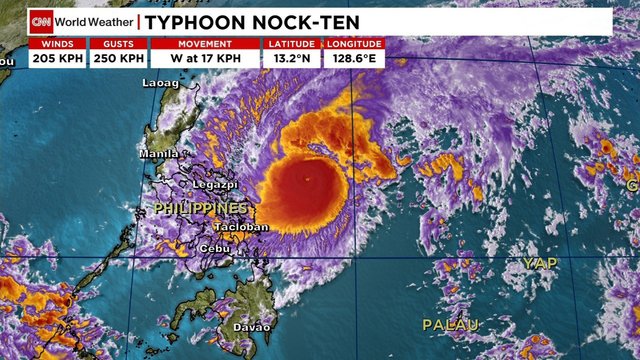
Typhoon Nock-Ten is threatening the Philippines, as it heads towards the area around the heavily-populated capital Manila.
Civil defense officials have been put on “red alert”, as Nock-Ten is due to hit Manila on December 26.
The typhoon has weakened since making landfall on the eastern coast on December 25, but it still packs winds up to 87mph, meteorologists say.
Three people were reported killed in Albay province, south-east of Manila.
Nock-Ten (known as Nina in the Philippines) has cut power lines and uprooted trees.
Manila’s civil defense office warned that the capital could be hit by “heavy to intense rains, flash floods and severe winds”.
Image source CNN
The coastguard has ordered beaches south of Manila to be cleared.
The storm hit the coast near Catanduanes Island on Christmas Day, knocking out power.
Hours later, local media reported that in Albay province a couple were swept away in a flash flood and an elderly man was killed by a collapsing wall.
About 100,000 people had been earlier moved from areas at risk in the Bicol region amid fears of widespread flooding and possible landslides.
There were fears Filipinos would ignore evacuation warnings to stay at home with family at Christmas, the biggest holiday in the largely Catholic nation.
Dozens of ports remain closed, with warnings of high waves.
Nock-Ten is expected to pass across the main island of Luzon, before heading into the South China Sea.
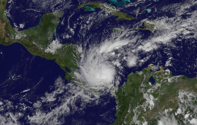
Caribbean storm Otto has been upgraded to a hurricane and is threatening Costa Rica and southern Nicaragua, forecasters say.
Forecasters warned that Hurricane Otto may have winds of 90 mph when it makes landfall early on November 24.
At least four people have already died in Panama in severe weather caused by the approach of the storm.
Otto is moving west at 2 mph after being almost stationary throughout November 22, experts say.
According to the US National Hurricane Center, Otto is now blowing at about 75 mph as it approaches northern Costa Rica and southern Nicaragua.
The storm is now centered east of Limon, Costa Rica. When it makes landfall on November 24 its heavy rain is expected to create numerous mudslides. It is then expected to cross over into the Pacific.
The Washington Post says that very few hurricanes have formed so late in the season – which ends on 30 November – and that across the Atlantic since 1851 only 35 storms have reached tropical storm intensity on or after November 15.
Earlier in Panama two people died in a mudslide; a girl drowned in a river and a boy died when a tree fell on a car taking him to school. His mother, who was driving, survived.
According to officials, about 50 homes were destroyed by mudslides and flights were delayed.
The governments of Nicaragua and Costa Rica have issued a hurricane watch from Costa Rica’s southern border to the city of Bluefields in Nicaragua.
There is also a likelihood of dangerous surf and rip current conditions over the next few days along the coasts of Panama, Costa Rica and Nicaragua, officials say.
Super Typhoon Haima hit the Philippines killing at least four people in the north of the country.
Haima, which brought sustained winds of up to 140mph, made landfall over the northern province of Cagayan on October 19.
Nearly 100,000 people were evacuated from threatened areas as Typhoon Haima approached.
Image source University of Colorado
There was widespread damage overnight, with homes destroyed and power lines brought down.
According to Filipino authorities, two of those killed were buried in a landslide, and two others buried in a shanty town in a mountainous region.
Experts had feared the storm could prove as destructive as the catastrophic super typhoon Haiyan, which claimed more than 7,350 lives in 2013.
The Philippines endures around 20 major storms every year, many of them deadly.
President Rodrigo Duterte, who was in Beijing on a state visit, had said he prayed the Philippines would be spared but that they were “ready”.
“We only pray we be spared the destruction such as previous times. Everything has been deployed.”
Haima was upgraded to a super typhoon just before it hit in Penablanca, a town in Cagayan province, around 23:00 local time on October 19.
On October 20, there were reports of damage across a wide area.
Haima, known as Lawin locally, had a weather band 500 miles wide, and authorities had warned the public to expect fierce winds and storm surges up to 16 feet or higher.
It is the second typhoon to hit the Philippines in a week, after Sarika struck on October 16. At least one person was killed in that storm, and three people are still missing.
Typhoon Haima is now moving out across the South China Sea towards Hong Kong and southern China.
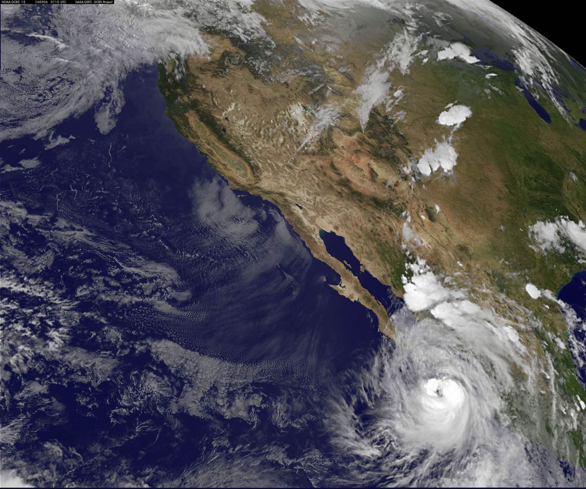
Mexican authorities are on high alert as Hurricane Newton is heading north-west towards the southern end of the Baja California peninsula with winds of about 75mph.
According to the US National Hurricane Center (NHC), Hurricane Newton could trigger flash floods.
The NHC warned that preparations to protect life and property “should be rushed to completion”.
On September 5, overcast skies in the Los Cabos municipality gave way to heavy rain and the wind was building in strength.
Image source NASA
Twelve shelters opened and drivers queued to fill their cars with fuel ahead of the hurricane’s arrival.
The same weather system lashed areas of the south-western state of Guerrero over the weekend before strengthening to a tropical storm.
Torrential rain that began on September 3 caused more than 30 mudslides across Guerrero, forcing main roads to close.
In Acapulco, floods and landslides affected dozens of homes and schools and about 200 people had to be rescued from a housing complex.
Newton reached hurricane strength over the Pacific on September 5, prompting the Mexican government to issue a hurricane warning for the west coast of Baja California Sur from north of Puerto Cortes to Cabo San Lazaro.
The region is a popular tourist destination.
The NHC said that at 15:00 local time, the eye of the hurricane was about 215 miles south-east of Cabo San Lucas and grinding towards the coast at about 16mph.
It said that on its current path, Hurricane Newton should be near or over the southern end of the peninsula on Tuesday morning, September 6.
The NHC said it would move across the peninsula and reach north-western Mexico early on September 7.
Over the weekend, Florida was battered by Hurricane Hermine, before it weakened to a post-tropical storm and drifted off the US east coast.
Hurricane Hermine has killed at least one person in Florida and caused severe damage along the state’s northern Gulf Coast.
Hermine is the first hurricane to hit Florida in eleven years.
As the storm pushed into Georgia, it knocked down power lines leaving hundreds of thousands without power.
Gusts of 80mph caused storm surges that flooded part of the coast.
Photo NASA
In Cedar Key, waters rose more than 9.5ft, among the highest surges ever seen, according to the National Weather Service.
After making landfall on September 2 in the morning, Hurricane Hermine swept through Florida and, weakening to a tropical storm, is now making its way towards South Carolina.
A tropical storm warning was issued for parts of New Jersey, Connecticut and New York City, the National Hurricane Center said.
The US Coast Guard also warned boaters and swimmers along the New York and New Jersey coasts to use caution in what is expected to be rough surf and hazardous rip currents this weekend.
Police in Taylor County, Florida, that has a population of more than 20,000, said the storm had inflicted “severe damage”.
In Tallahassee, where people were urged to move to higher ground to avoid flash floods, at least 70,000 homes were without power at one point, affecting 60% of people in the region.
Florida Gov. Rick Scott had earlier declared a state of emergency for 51 counties across the state.
According to weather officials, Hurricane Hermine could bring heavy rains along the East Coast in the coming days.
In Georgia, Gov. Nathan Deal also declared a state of emergency, for 56 counties, but the state was spared the havoc it had expected.
“We’re having a bit of a sigh of relief,” said Jim Butterworth, director of the Georgia Emergency Management Agency.
However, 107,000 customers were reported to be without power across the state as crews worked to repair damage.
Some models show that Hurricane Hermine will stall near the New Jersey coast next week, potentially bringing prolonged heavy rain to the area.
Hurricane Hermine has become the first to hit Florida in 11 years.
Hermine has made landfall in northern Florida early on September 2 as a Category one hurricane, bringing with it a heavy storm surge.
Florida Governor Rick Scott declared a state of emergency for 51 counties as residents were braced for the dangerous storm.
Wind gusts reached 80mph on September 1, the National Hurricane Center (NHC) said.
City officials in the state capital Tallahassee, which is in the path of the storm, said at least 70,000 homes were now without power.
Photo Wikipedia
Tallahassee weather officials warned of the risk of flash floods and urged people there to move to higher ground, but winds have now started to reduce as the storm moves inland.
While the area is prone to storms and storm surges, it has not seen a hurricane in close to 4,000 days.
The last hurricane to strike Florida was Wilma in October 2005, which made landfall in the same year as Katrina and caused five deaths and an estimated $23 billion of damage.
Gov. Rick Scott said: “This is life threatening. We have not had a hurricane in years.”
He added that 8,000 members of the Florida National Guard were prepared to be deployed in the wake of the storm.
Rick Scott ordered evacuations in five counties in Florida’s north-west and called for voluntary evacuations in three other coastal counties.
St Petersburg was littered with downed palm fronds and tree branches, and low-lying streets were flooded.
According to weather officials, Hurricane Hermine will also hit Georgia and the Carolinas, and could bring heavy rains along the East Coast in the coming days.
Georgia Gov. Nathan Deal has declared a state of emergency for 56 counties.
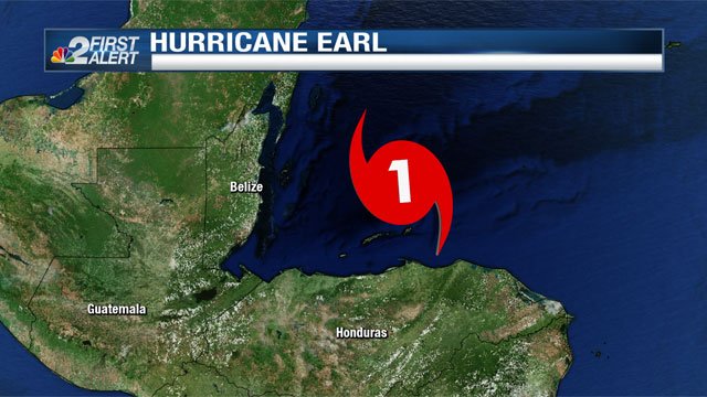
Hurricane Earl makes landfall in Belize, in Central America, the US National Hurricane Center has announced.
Earl now has speeds of up to 80mph, with the eye of the storm now passing just north of Belize City.
Belize’s National Emergency Management Organization (NEMO) warned of flash flooding and mudslides in Earl’s wake.
Heavy rains have fallen on Honduras. The storm is forecast to continue through northern Guatemala into Mexico.
Authorities have urged Belize City residents and other coastal communities to move inland and take advantage of higher ground or a network of storm shelters.
Officials ordered the closure of Belize City’s international airport while archaeological reserves and national parks were also shut.
Photo NBC
The storm is expected to lessen when as it moves inland.
In the meantime, NEMO officials say heavy rain could cause flash floods and mudslides, with a storm surge possible along the shore.
They have warned of trees being blown down, power cuts and damage to houses and buildings which will be hit by flying objects and projectiles.
After Earl passes through across Belize, it is expected to go through a northern rural part of Guatemala and from there into south-eastern Mexico.
Guatemala at this time of the year has its rainy season with often fatal flooding and mudslides.
Meanwhile, Mexican authorities say that the southern states of Campeche, Quintana Roo, Tabasco and Yucatan are likely to be affected by Earl and have issued an alert.
The storm knocked over a large numbers of trees and utility poles in Honduras, officials say.
At least nine people died on August 1 in Haiti and the Dominican Republic as the storm passed over the Caribbean.
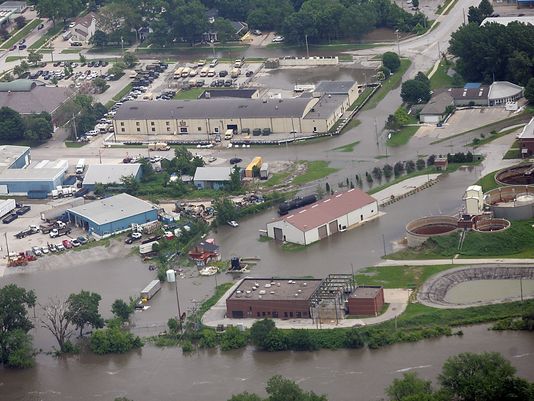
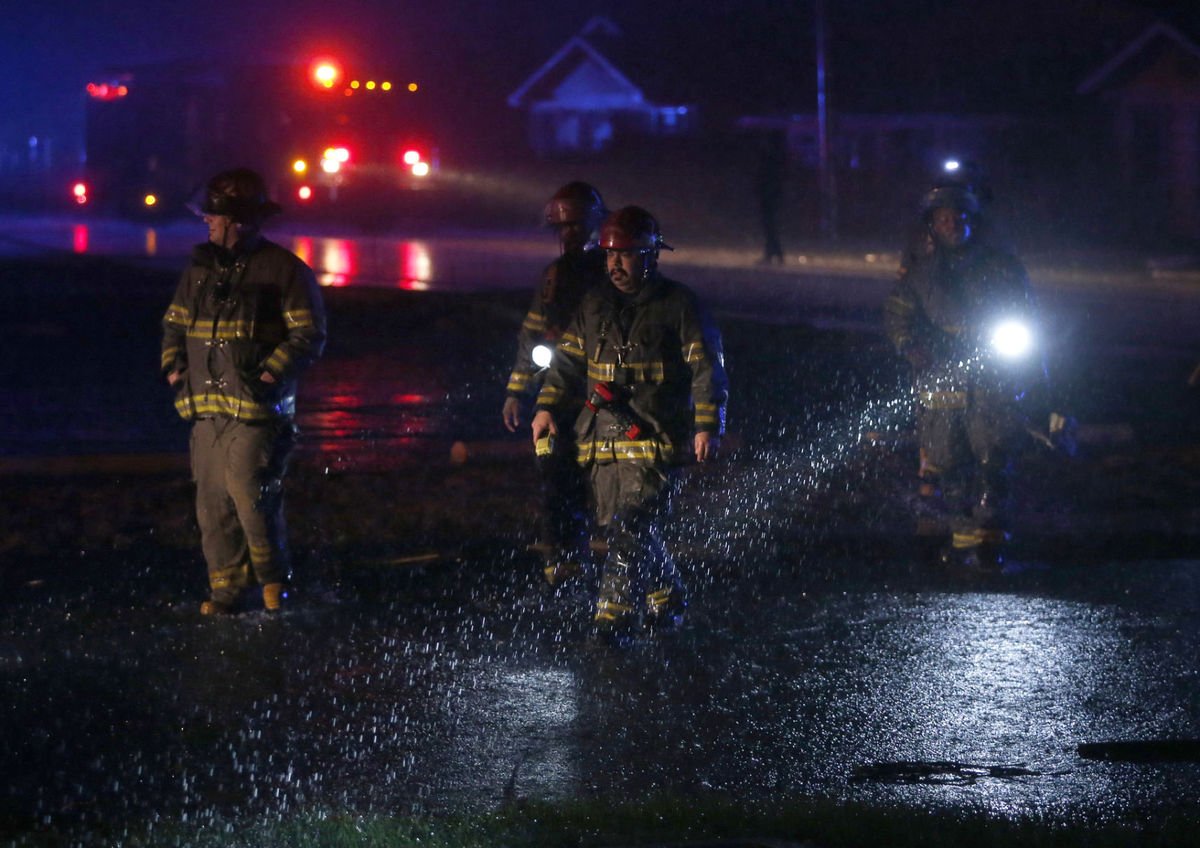
Rivers in Midwest brought flood warnings for over 12 million people on December 30 as scores of buildings were submerged after days of intense rain in which 24 people have died.
Two rivers west of St. Louis crested at historic levels, flooding local towns, disabling sewer plants and forcing the evacuation of hundreds of residents.
Major rivers including the Mississippi are expected to reach record highs as flood waters rush toward the Gulf of Mexico, the National Weather Service said.
The flooding has closed many roads and parts of I-44, a major artery running from west Texas to St. Louis. It poses a threat to livestock and crops in farm areas stretching from Illinois to Louisiana.
Water rose to the rooftops of homes and businesses in Missouri, where Governor Jay Nixon called the flooding “historic and dangerous”.
Jay Nixon spoke with President Barack Obama on December 30 and received a pledge of federal support.
About 300 people in Valley Park, Missouri, west of St. Louis, were evacuated in case a levee is breached on the Meramec River, said Chief Rick Wilken of the Valley Park Fire District.
At least 24 people have died, mostly from driving into flooded areas, in Missouri, Illinois, Arkansas and Oklahoma after days of downpours with as much as 12 inches of rain.
In Eureka, Missouri, along the Meramec River, Mayor Kevin Coffey said a man was rescued from atop the cab of his pick-up truck after spending the night in a parking lot to watch over his gun shop business.
Historic floods on the Mississippi in 1993, 1995 and 2011 occurred during warm weather, after snow melts in the north.
While the rains have stopped for now, freezing weather is setting in.
Agriculture experts said water standing more than a week could kill the soft red winter wheat crop. Export premiums for corn and soybeans were at their highest levels in weeks because of stalled barge traffic on swollen rivers.
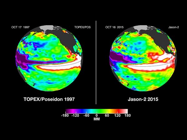
NASA has warned that the effects of the current El Nino weather phenomenon could be as bad as those of 1998, the strongest on record.
That El Nino played havoc with world weather systems and was blamed for several extreme weather events.
The current El Nino has been linked to several floods and unusually warm conditions in the northern hemisphere.
The phenomenon sees warm waters of the central Pacific expand eastwards towards North and South America.
El Nino, which occurs every two to seven years, usually peaks late in the calendar year, although the effects can persist well into the following spring and last up to 12 months.
Photo NASA
NASA says the current El Nino “shows no signs of waning”, based on the latest satellite image of the Pacific Ocean.
It bears “a striking resemblance” to one from December 1997, NASA says, “the signature of a big and powerful El Nino”.
This year’s El Nino has been linked to the worst floods seen in 50 years in Paraguay, Argentina, Uruguay and Brazil.
The floods there have forced more than 150,000 people from their homes.
More than 100,000 of those have been in the Paraguayan capital Asuncion alone.
In the US, 13 people have died in Missouri as a result of flooded rivers after tornadoes and storms hit the region.
El Nino has also been cited as a factor in the floods that have hit northern parts of the UK, forcing thousands from their homes and leaving thousands more without power.
Storm Frank, which is expected to bring fresh rain and flooding to the UK this week, is part of a weather system which could see temperatures at the North Pole 50F higher than normal for this time of year.
Higher temperatures than the seasonal average have been noted in many parts of Europe and the US.
Average temperatures on Christmas Day in France were the second highest on record, just below those of 1997.
The mild weather has forced farmers to harvest crops such as salad, strawberries and asparagus early, with reports of large amounts of produce going to waste.
In Italy, experts say the unusually calm and dry weather has exacerbated pollution over the cities of Milan and Rome.
By contrast, in Mexico El Nino is being blamed for freezing temperatures in the north of the country, with snow seen in parts of the Sonoran desert for the first time in 33 years. Three deaths have been blamed on the cold in Sonora.
More than 40 people have been killed over the past five days by severe storms in the South and Midwest.
Flash floods, tornadoes and now snow have destroyed hundreds of homes and businesses and snarled transport links.
The National Weather Service has issued tornado warnings for Texas, Arkansas, Louisiana, Oklahoma and Mississippi.
The governors of Missouri, Oklahoma, and New Mexico have declared states of emergency.
In Illinois, three adults and two children were swept away in their car by the flood waters. In Texas, at least 11 people were killed by powerful tornadoes with winds of up to 200 miles an hour.
Hundreds of homes in Texas were reduced to rubble and cars were blown off the road. Five people died in their cars on a highway passing the city of Garland. Pedro Barineau of the local police said they had no chance.
“There were sirens that were going off, I mean multiple times and in multiple areas, notifying people of a tornado. However, people on the highway that were driving through they had no idea that the sirens were going off and the tornado was on them in a matter of seconds,” he said.
Texas Governor Greg Abbott said his office had declared Dallas County and three nearby counties a disaster area. He also warned people to be wary of snow in western parts of the state and of rivers spilling their banks.
Parts of New Mexico, where a state-wide emergency has been declared, are expecting up to 2ft of snow. The New Mexico city of Roswell recorded 12.3 inches of snow on December 27 – an area record for a single day.
Oklahoma Governor Mary Fallin declared a state of emergency on December 27 in anticipation of blizzard conditions and an ice storm.
The bad weather forced the cancellation of nearly 1,500 flights on December 27, according to tracking service FlightAware.com. About half of the cancelled flights were in Dallas, a major US flight hub.
While extreme weather in the United States around Christmas is not unknown, meteorologists say that unseasonably high temperatures in some areas contributed to the severity of the storms.
The forecast for the eastern US is for high temperatures to continue – Washington DC pushed close to 70F on December 27.
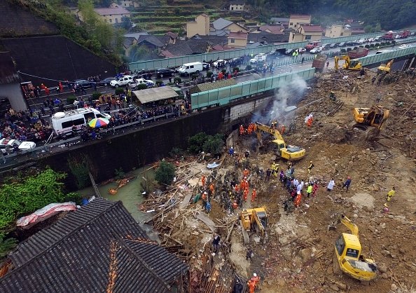
At least 25 people are confirmed dead after a landslide hit Zhejiang province in eastern China.
More than 2,000 rescuers are searching for survivors in Lidong village after several days of rain sparked a torrent of mud and rock.
The landslide occurred shortly before 23:00 on November 13 and buried almost 30 houses.
Photo Getty Images
Parts of the village remain flooded, hindering rescue efforts. Reports say 12 people are still missing.
Local officials said one person had been rescued so far and is in stable condition.
As well as rescuers, sniffer dogs and machinery, psychologists have also been dispatched to the area to help family members of the victims, local officials said.
Most of the missing people are children and the elderly, according to local media, which also said that compensation had been agreed for those who lost homes in the disaster.
This website has updated its privacy policy in compliance with EU GDPR 2016/679. Please read this to review the updates about which personal data we collect on our site. By continuing to use this site, you are agreeing to our updated policy. AcceptRejectRead More
Privacy & Cookies Policy
Privacy Overview
This website uses cookies to improve your experience while you navigate through the website. Out of these, the cookies that are categorized as necessary are stored on your browser as they are essential for the working of basic functionalities of the website. We also use third-party cookies that help us analyze and understand how you use this website. These cookies will be stored in your browser only with your consent. You also have the option to opt-out of these cookies. But opting out of some of these cookies may affect your browsing experience.
Necessary cookies are absolutely essential for the website to function properly. This category only includes cookies that ensures basic functionalities and security features of the website. These cookies do not store any personal information.
Any cookies that may not be particularly necessary for the website to function and is used specifically to collect user personal data via analytics, ads, other embedded contents are termed as non-necessary cookies. It is mandatory to procure user consent prior to running these cookies on your website.