Home Tags Posts tagged with "Ice storms"
Ice storms
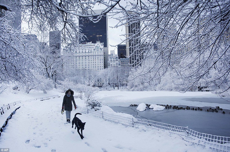
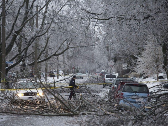
The “catastrophic” winter storm that gridlocked traffic, left flights cancelled, and knocked out power in the East Coast, has pushed into eastern Canada.
As much as 24in was expected to fall in some areas by the end of Friday, blown about by heavy winds from Quebec to Newfoundland.
Authorities closed a 124 mile section of the Trans-Canada Highway in Quebec.
The storm has been blamed for the deaths of more than two dozen people.
In the US, about half a million of people and businesses remained without power in the typically mild southern states on Friday, some for a third day, after the storm destroyed power lines and knocked down trees.
The weather system tapered off as it crawled farther north, but was still strong enough to bring almost 30cm of snow to areas of Quebec and parts of Newfoundland on Friday, with high winds of more than 60 mph.
Other parts of the eastern provinces and Nova Scotia saw heavy rain from the same storm.
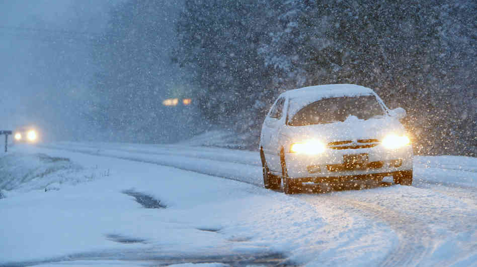
In eastern Quebec, several motorways, including the Trans-Canada Highway from Quebec City to Riviere-du-Loup, were partially shut after the snow and high winds dangerously hindered visibility.
The “catastrophic” winter storm that gridlocked traffic, left flights cancelled, and knocked out power in the East Coast, has pushed into eastern Canada
Canadian weather officials have issued a number of winter storm warnings as another unrelated system is expected to bring severe weather to the Atlantic Provinces again on Saturday and Sunday.
The storm struck first on Wednesday in the US South, where it covered trees and power lines with as much as an inch of ice and caused traffic jams across the region.
South Carolina Governor Nikki Haley compared the damage to the aftermath of a hurricane.
One electric co-operative in the state lost 50 poles in the ice storm, compared to 21 in the last cyclone, officials said. Those still in the dark in the US South may wait several more days before electricity is restored.
The storm then moved up the East Coast, dumping heavy snow from North Carolina to Boston over a 24-hour period. Parts of New York state saw as much as 27in.
Washington-area offices of the US federal government were closed on Thursday to spare workers the dangerous commute.
At least 25 deaths have been blamed on the storm.
In the US, road conditions remained treacherous in some areas on Friday. Thirty people were injured, five severely, in a multiple vehicle pile-up near Philadelphia on Friday morning.
Officials said it would take many hours to clear damaged vehicles, including lorries. The crash spawned a traffic jam stretching for 5 miles.
Many schools remained closed in eight states from Virginia to Maine. Almost 1,700 flights were cancelled on Friday, and 6,500 a day earlier.
The foul weather also has delayed tens of thousands of deliveries of Valentine’s Day flowers.
Meanwhile, a sheriff in north-eastern Georgia declared in an apparently tongue-in-cheek Facebook post that the weather had rendered the Oconee County region a “No Valentines [sic] Day Zone”.
Sheriff Scott Berry declared all men in the area were exempt from having to buy chocolate or other gifts for their partners until next Tuesday.
[youtube YBw8Lbvyhh4 650]
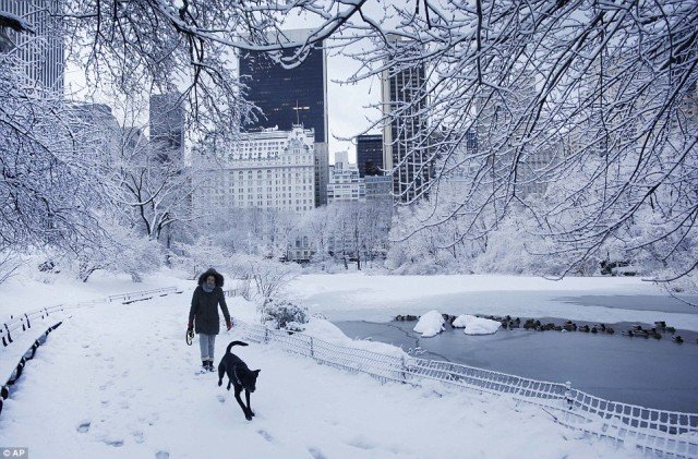
A “catastrophic” winter storm is unleashing a second wave of heavy snowfall on the US Northeast, as hundreds of thousands of people remain without power in the states in its southern wake.
About 550,000 homes and businesses are still in the dark and almost 1,000 Friday flights are cancelled.
The ice storm has been blamed for at least 22 deaths, including that of a pregnant woman struck by a snowplough.
It is the latest miserable weather to pummel the winter-weary eastern US.
Early this month, Washington DC, Detroit, Boston, Chicago, New York and St Louis had recorded two to three times as much snow as normal by this time in the winter season.
This storm system has already dumped as much as 15in of snow in the Washington DC region and 8in around New York City by Thursday.
Up to another foot is forecast in a second snowfall that began on Thursday evening and is expected to continue through Friday morning, with the heaviest precipitation in the US states of Connecticut and Massachusetts.
The National Weather Service predicted the weather would ease by the weekend.
“Heavy snow will continue tonight… but will begin to taper off from south to north through the morning hours on Friday,” the official forecaster said.
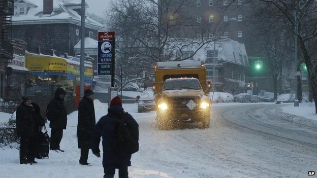
The snow-covered streets in the nation’s capital were largely deserted on Thursday, after the federal government closed its Washington-area offices to spare its widely dispersed workforce the trouble and danger of the drive to work.

A second wave of heavy snowfall hits the US Northeast
On Friday, official Washington will start work two hours behind the ordinary schedule, the Office of Personnel Management said.
More than 6,500 US flights were cancelled on Thursday, according to airline-tracking website FlightAware.com. Another 1,000 on Friday’s schedule have already been grounded.
In New York City, Mayor Bill de Blasio was criticized for keeping schools open on Thursday despite the snow piling on the ground.
The head of the city schools teachers union said it was a “mistake” to have students, parents and school staff travelling under such conditions, while a prominent meteorologist and television personality opened a public spat on Twitter with the mayor.
“It’s going to take some kid or kids getting hurt before this goofball policy gets changed,” Al Roker of NBC wrote on Twitter from Sochi, Russia, where he is covering the Winter Olympics. Al Roker has a daughter in the city schools.
Bill de Blasio responded that many parents depended on schools to watch over their children while they work – and noted the city had closed schools only 11 times for snow since 1978.
“We were convinced that kids could get to schools this morning,” he said.
The multi-day storm has been blamed for almost two dozen deaths.
In New York City on Thursday, a pregnant woman was killed after being struck by a snowplough. Her baby was delivered in critical condition via caesarean section.
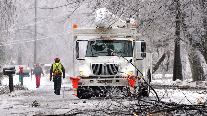
The storm moved into the north-east on Wednesday night and Thursday morning, leaving in its southern wake a wreckage of snapped tree branches and power lines coated in as much as an inch of ice.
Most of the remaining power cuts are in South Carolina and Georgia, where President Barack Obama declared a disaster, opening the way for federal aid.
Forecasters said it was one of the worst storms to strike Atlanta, the largest city in the South, since 1973.
[youtube KOFqtf_slDc 650]
A second vicious ice storm in as many weeks caused widespread power outages in Southeast leaving more than half a million people in dark.
Georgia was the worst-hit state with almost 230,000 homes and businesses without electricity, according to figures reported by utility companies at 6:45 a.m. ET.
More than 200,000 customers were experiencing outages in South Carolina with 90,000 others suffering in North Carolina. Louisiana and Virginia also had thousands of people left without electricityl.
Almost 500,000 Georgia Power customers alone had been off the grid, but the company had managed to restore more than half of them.
The Southeast was suffering after being hit Wednesday by a huge storm that stretched from Alabama to Massachusetts.

The ice storm caused widespread power outages in Southeast leaving more than half a million people in dark
But during the night, those without power were not the only people suffering: Ice and fallen trees created dangerous driving conditions for crews trying to get people back on the grid, according to the Georgia Department of Transportation.
More than 3,400 flights into and out of U.S. airports were canceled Wednesday and 3,500 more were delayed. By 3:30 a.m. ET Thursday there were already more than 1,600 US cancelations for the day, according to FlightAware.
By early Thursday, the storm had begun its march up the East Coast, according to Kevin Roth, lead meteorologist at The Weather Channel.
In New York, Pennsylvania, and Washington, D.C., it was expected to dump snow at a furious rate of two inches per hour, making tough work for even the most industrious snowplow crews.
The freezing rain had largely stopped in the South but this was due to morph into snow in parts of Georgia and Alabama, Kevin Roth said.
But with temperatures still below freezing, the ice which built up in parts of Georgia and the Carolinas on Wednesday was not expected to budge. And this was continuing to affect the states’ electricity infrastructure.
As much as an inch of ice built up in all these states, bringing down trees and weighing heavy on fragile power lines. The worst-affected areas were north and east Georgia, central and eastern South Carolina, and central and eastern North Carolina.
[youtube 7WrX4SP7eNc 650]
A massive ice storm is now poised to pummel the US East Coast after wreaking havoc in the South, say forecasters.
More than 350,000 people are reportedly without power and 3,000 US flights have been cancelled due to ice and strong winds.
Nearly empty roadways were reported as many heeded warnings to stay indoors.

More than 350,000 people are reportedly without power and 3,000 US flights have been cancelled due to ice and strong winds
North Carolina and Virginia are bracing for up to 1ft of snow as the storm rolls north.
It is predicted to drop up to 8in of snow in Washington DC and up to 10in in New York overnight.
At least five traffic accident deaths were blamed on ice in Texas and Mississippi.
The National Weather Service said it was an event of “historical proportions”, drawing comparisons with similar weather systems that struck the Atlanta area in 2000 and 1973.
[youtube 41xQEpdey7s 650]
A snow storm spawned traffic chaos in the Deep South leaving thousands of people stranded overnight on motorways, in schools and churches.
Airports and roads were closed as five states declared emergencies.
Military vehicles were deployed to aid stuck motorists and to reach those in need of food and water.
Barely 3in of snow caused havoc in a warm-weather region where many cities do not even have snow ploughs or fleets of salt trucks.
Hundreds of road accidents were reported, a number of them involving trucks jackknifing on highways.
Despite ample weather warnings, school officials waited until the middle of Tuesday when snow was already falling to send students home on routes where traffic was grinding to a halt.
Nearly 8,000 students across Georgia and Alabama spent the night in school gyms or on buses, reports ABC News.
Many commuters abandoned cars along jammed motorways to seek shelter in churches and fire stations.

A snow storm spawned traffic chaos in the Deep South leaving thousands of people stranded overnight on motorways, in schools and churches
Gridlock on the streets of Atlanta, Georgia, was so bad that a police officer had to deliver a baby on a snowy motorway.
Georgia Governor Nathan Deal said on Wednesday morning that the National Guard had sent military Humvees on to the city’s motorways to move stranded school buses and provide food and water to people.
A school bus flipped over as it was driving students home amid dismal weather near Asheville, North Carolina.
Motorists were instructed to stay off roadways in Louisiana, Mississippi, Georgia, North Carolina and South Carolina, where states of emergency were declared.
“Residents should not overreact but should make plans now to ensure they are prepared for prolonged freezing conditions and icy roadways,” Mississippi Governor Phil Bryant told US media.
At least five people were killed due to weather-related accidents in Alabama on Tuesday.
New Orleans’ main airport, which was closed on Tuesday, has reopened with a reduced service.
Some 1,700 flights across the US were grounded on Wednesday.
State legislature activities in South Carolina were also cancelled due to weather.
The latest cold snap stretched across much of the US on Wednesday, sending temperatures as low as -30F.
[youtube i5ywebF1xo8 650]
According to forecasters, Deep South will be hit by what could be its worst snow and ice in a generation.
Schools were closed, hundreds of flights were scrapped and cities blew the dust off the few snowplows they have Tuesday.
From Texas to the Carolinas, almost 40 million people are in the storm’s path.
In New Bern, North Carolina, where the last 6-inch snowfall happened in 1989, forecasters said as much as 7 inches could come down. In Charleston, South Carolina, and Savannah, Georgia, ice was the major threat – as much as a half-inch.
Columbia, South Carolina, a city of 130,000 people with only eight snowplows, was expecting up to 4 inches of snow. The city put emergency workers on 12-hour shifts and mixed up sand, salt and brine to put on the city’s major roadways as the weather got worse.
Schools were closed from Texas through the Florida Panhandle and up to North Carolina. The Johnson Space Center in Houston shut down for the day. Mississippi Gov. Phil Bryant declared a state of emergency for almost half the state’s counties.

Deep South will be hit by what could be its worst snow and ice in a generation
Drivers were warned to use extreme caution or stay home entirely. Just north of Austin, Texas, where ice was accumulating on bridges and overpasses, emergency crews responded to a reported 20-car wreck.
Airlines canceled more than 2,600 flights, including more than 800 in the hub of Atlanta and more than 600 at the major airport in Houston.
Snow was already falling Tuesday morning from just north of Austin, Texas, up to the southern tip of Maryland, and a band of ice reached from San Antonio to the suburbs south of Atlanta.
By Wednesday, forecasters said, the storm will bend up the East Coast, traveling as far north as Providence, Rhode Island, before moving offshore by lunch.
Farther north, millions of people suffered Tuesday under another day of deep freeze. Subzero temperatures stretched from Montana to Pennsylvania. It was 11 below zero as the sun came up in Chicago, 8 below in Pittsburgh and 6 below in Cincinnati.
The unbearable cold forced schools to close in Minnesota, Chicago and western Pennsylvania. The University of Michigan shut down because of weather for the first time since 1978. Lake Geneva, Wis., recorded its 17th day of subzero temperatures this winter, double the average.
The latest blast of frigid weather arrived just as a shortage of propane, the fuel used by 14 million Americans to heat their homes, reached critical proportion.
With prices more than doubling from $2 a gallon to more than $4 last week, the governors of Minnesota and Illinois declared states of emergency Monday, urging people to cut back and regulators to lift restrictions on shipping to their states.
[youtube xez5TgqN1zM 650]
A second major winter storm will hit the East Coast with up to 12in of snow, blowing wind and bitter cold forecast.
Even before the first flakes had fallen, the government offices in Washington DC and schools in several states were closed pre-emptively.
In New York, snow began falling during the morning commute, and authorities warn of hazardous road conditions.
And more than 2,500 flights have already been cancelled.
The storm comes just two weeks after a weather pattern known as the polar vortex brought heavy snow and record low temperatures to the eastern half of the US.

A second major winter storm will hit the East Coast with up to 12in of snow, blowing wind and bitter cold forecast
Winter storm warnings have been declared from West Virginia to Boston, with some of the heaviest accumulations threatened along the coastal cities.
Washington DC is expected to see its heaviest snow fall in three years, and temperatures across the eastern US are expected to be 10 to 25 degrees colder than average on Tuesday and Wednesday, according to the National Weather Service.
As the snow began falling in Washington DC, the White House cancelled its daily press briefing and a meeting of President Barack Obama’s commission on electoral administration.
The weather has also affected New Jersey Governor Chris Christie’s second inauguration. Organizers have cancelled the party scheduled for Tuesday night on Ellis Island in New York Harbor.
[youtube sd8Ng6wUhhs 650]
All 50 US states saw freezing temperatures as weather records have tumbled across North America.
The most extreme arctic blasts, blamed on a weather pattern known as the polar vortex, were said to have affected nearly 190 million people.
In Kentucky, an escaped prisoner turned himself in to get out of the cold.
Some parts of the Midwest hit -26C (-14F), as low as the Antarctic coast in winter, and much colder than the inside of a domestic freezer.
Temperature records were shattered in states across the US, including Alabama, Georgia, Tennessee, Arkansas, Michigan, Maryland, Ohio, Pennsylvania and New York.
It was -17C (1F) in the small town of Hell, Michigan, prompting online jokes that the weather was so bad even hell had frozen over.
But it was Embarrass, Minnesota, that experienced the lowest temperature in the nation on Tuesday: -37C (-35F).
That was colder than readings recently recorded on the Red Planet by the Mars Rover.

All 50 US states saw freezing temperatures as weather records have tumbled across North America
A video of a meteorologist tossing a pot of boiling water into the air in Wisconsin, to demonstrate how it immediately turns to snow, quickly went viral on the internet and was widely imitated.
The extreme weather resulted in the usual travel chaos – nearly 2,700 US flights were cancelled on Tuesday.
More than 500 rail passengers on their way to Chicago were marooned overnight into Tuesday morning in northern Illinois on three Amtrak passenger trains after drifting snow and ice covered the tracks.
The big freeze was even testing the resolve of Canadians, no strangers to cold weather.
Temperatures in parts of Ontario fell to -30C (-22F), causing flights in and out of Pearson International Airport to be halted for several hours on Tuesday morning.
Roads in the cities of Toronto and Ottawa were coated in dangerous black ice.
Freezing temperatures were recorded in all 50 US states, including the usually balmy California and Florida.
Even tropical Hawaii experienced -7C (18F), reports the Associated Press news agency, although that was at the peak of Mauna Kea, a dormant volcano.
Atlanta, Georgia, was 25 degrees below average for this time of year.
People in the Midwest are still digging out from two massive snow storms recently which dumped more than 2ft of snow.
A reprieve is expected soon, however, with forecasters predicting temperatures above freezing for much of the US in the coming days.
[youtube hlEkS_MuS8g 650]
The Northeast and Upper Midwest are braced for potentially record-breaking low temperatures as a “polar vortex” brings more freezing weather.
A winter storm has already blanketed areas of Canada and the north-eastern US with up to 2ft of snow.
The snow storm has been blamed for 16 deaths in recent days and the cancellation of more than 3,700 flights this weekend.
Schools in Chicago are among those closing as officials tell people to stay indoors on Monday.
Meanwhile, a plane from Toronto slid into snow as it turned onto a taxiway after landing at New York’s JFK airport on Sunday.
No-one was hurt in the incident but all flights at the airport were suspended for two hours because of icy runways.
The plunging temperatures result from the polar vortex, an anti-clockwise pool of cold, dense air.
Forecasters say temperatures in the north and central US could feel as low as -60F (-51C) with the effect of wind chill.
Authorities have warned residents to remain indoors, both for their own safety and to keep roads clear for snow removal.

The Northeast and Upper Midwest are braced for potentially record-breaking low temperatures as a “polar vortex” brings more freezing weather
In Canada, thousands of people on the island of Newfoundland remain without power due to a transformer fire linked to heavy snow.
“The coldest weather in years will be making its presence known from the Upper Midwest to the Mid-Atlantic region for the beginning of the work week,” the US National Weather Service said in a statement.
The states of Ohio, South Dakota and Illinois are among those set to be hit. Tennessee and Kentucky are forecast to see several inches of snow.
The weather service said “an incredibly strong surge of bitterly cold Arctic air” was sweeping across the country until Tuesday.
It is set to continue to the north-east, where residents are still digging out from the week’s deadly snowstorm.
It could bring some of the coldest temperatures in two decades.
In Canada, the temperature dropped as low as -20F (-29C) in Toronto and -36F (-38C) in Quebec City with wind chill on Thursday – the lowest seen in at least two decades there.
Heavy snow has also affected US states including New York, Connecticut and Massachusetts. Boston was said to be the worst hit with nearly 18 in of snow.
Schools have also been closed across the state of Minnesota for Monday, as well as for parts of Wisconsin, Illinois and Indiana, among others.
Officials in Chicago, Illinois reversed a decision to keep schools open following criticism from a teachers’ union, according to the Associated Press.
State offices were to stay closed in neighboring Indiana where a state of emergency was declared in Lake County in the northwest, allowing only emergency or law enforcement vehicles on the roads.
The Green Bay Packers football team handed out hot chocolate and hand warmers to fans at a game being played in Wisconsin on Sunday. Doctors had urged fans to wear at least three layers of clothing.
Sixteen deaths have been blamed on the wide-ranging storm, according to the Associated Press news agency.
[youtube dDXOH0miEQI 650]
The Midwest is bracing for potentially record-breaking low temperatures as an Arctic chill brings more freezing weather.
A winter storm has already blanketed areas of Canada and the north-eastern US with up to 2ft of snow.
It has been blamed for 16 deaths and the cancellation of more than 5,000 flights since Wednesday.
Forecasters say temperatures in the Midwest could feel as low as -58F (-50C) with the effect of wind chill.
Authorities have warned residents to remain indoors, both for their own safety and to keep roads clear for snow removal.
In Canada, tens of thousands of people on the island of Newfoundland remain without power due to a transformer fire linked to heavy snow.
“The coldest weather in years will be making its presence known from the Upper Midwest to the Mid-Atlantic region,” the US National Weather Service said in statement.
The states of Ohio, South Dakota and Illinois are among those set to be hit.
The weather service said “an incredibly strong surge of bitterly cold Arctic air” would sweep across the country from Saturday night until Tuesday.
It is set to continue to the north-east, where residents are still digging out from the week’s deadly snowstorm.
The Midwest is bracing for potentially record-breaking low temperatures as an Arctic chill brings more freezing weather
It could bring some of the coldest temperatures in two decades.
“The last really big Arctic outbreak was 1994,” Reuters news agency quoted Bob Oravec, a forecaster with the National Weather Service, as saying.
“Outbreaks like this don’t occur everyday.”
In Canada, the temperature dropped as low as -29C (-20F) in Toronto and -38C in Quebec City with wind chill on Thursday – the lowest seen in at least two decades there.
Heavy snow has also affected states including New York, Connecticut and Massachusetts, with school closed, transport systems drawn to a halt and residents told to stay at home.
Boston was said to be the worst hit with nearly 18in of snow.
Sixteen deaths have been blamed on the wide-ranging storm, according to the Associated Press news agency.
A salt storage worker was killed in Philadelphia when a 100-ft pile of road salt fell and crushed him. A woman suffering from Alzheimer’s disease in New York state froze to death after she wandered away from her rural home.
Some 1,200 flights were cancelled across the US and about 6,000 flights delayed on Saturday, according to reports. This followed more than 4,000 cancellations earlier in the week.
Chicago’s O’Hare International Airport and Newark Liberty International Airport in New Jersey were said to be among the worst affected.
[youtube AMCLegTUGdw 650]
This weekend will bring a deep freeze that could prove fatal for the ill-equipped across the Midwest.
States such as Illinois, Minnesota and Wisconsin will see lows in the minus teens and minus 20s. And with sub-zero winds whipping through some areas, it could feel more like the minus 50s and minus 60s, meteorologists warn.
The Weather Channel warned that “one of the coldest arctic air masses in nearly 30 years” was likely to hit the Plains and Midwest this weekend. Some all-time cold records appeared to be in jeopardy, forecasters said.
Snow is expected to begin falling throughout the Midwest on Sunday, also reaching parts of Tennessee and Alabama. Along the East Coast, the storm will bring rain but be accompanied by warmer weather.
Minnesota isn’t taking any chances on Monday. Governor Mark Dayton said all public schools will be closed for the day.
Minneapolis will see a high of minus-14 degrees and a low of minus 27 degrees through Monday – but with the wind chill it would feel like the minus 40s.
“The safety of Minnesota’s schoolchildren must be our first priority,” Mark Dayton said in a statement.

One of the coldest arctic air masses in nearly 30 years is likely to hit the Plains and Midwest this weekend
“I have made this decision to protect all our children from the dangerously cold temperatures now forecasted for next Monday. I encourage Minnesotans of all ages to exercise caution in these extreme weather conditions.”
Temperatures won’t be any better in Chicago, which will come close to a high of minus 11 degrees – a record mark previously reached in December 1983 and January 1994.
Perhaps the most foolhardy will be football fans in Wisconsin. Sunday’s NFC wild-card game between the Green Bay Packers and the San Francisco 49ers will play out in bone-chilling minus-5-degree temperatures.
Meanwhile, cities across the mid-Atlantic to the Northeast will see milder temperatures with rain Sunday into Monday. New York City will see highs in the lower 40s. Boston, digging out from as much as two feet of snow, could reach 50 degrees.
While airports in the areas hardest hit by Friday’s big storm still grappled with some residual flight problems, less than 800 into or out of the U.S. had been canceled as of 11 a.m. ET Saturday, according to FlightAware. More than 2,600 flights into or out of the U.S. were canceled by midday Friday.
New York’s John F. Kennedy International Airport, which reported 192 cancelled flights due to “zero visibility and high winds” at midday Friday, cut that number to 37 on Saturday morning. The trend carried to other area airports; La Guardia only reported 25 canceled flights on Saturday as compared with Friday’s 271, and Newark slashed its numbers from 285 to 37.
Boston’s Logan International Airport reported 23 cancellations Saturday morning and most other U.S. airports reported cancellations in the teens or single digits.
While the next wave of northeast weather might not affect air travel, another frigid plunge is forecast for Tuesday: New York City is expected to see a high of around 10 degrees, while Philadelphia and Boston will be in the teens.
[youtube B4L84C6tjQc 650]
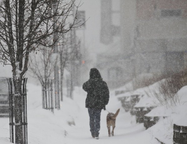
A massive winter storm has blanketed the Northeast with up to 2 ft snow and ushered in dangerously cold temperatures Friday, leaving travelers stranded and a cutting a deadly path across several states.
The storm has been blamed for 11 deaths and forced the cancellation of more than 4,000 flights since Wednesday.
Authorities warned residents to remain indoors, both for their own safety and to keep roads clear for snow removal.
Fatal traffic accidents occurred in New York, Michigan, Kentucky, Indiana and Illinois. Authorities said a woman suffering from Alzheimer’s disease froze to death after she wandered away from her rural western New York home.
And in suburban Philadelphia, as the storm approached, a worker at a salt storage facility was killed when a 100-foot-tall pile of road salt fell and crushed him. Falls Township police said the man was trapped while operating a backhoe.
The big storm followed closely the blueprint meteorologists drew up, slamming the Northeast overnight Thursday with as much as two feet of snow and sub-zero wind chills through Friday. The biting wind and blowing snow shut down interstates and airports alike and gave millions of school children a snow day.
John F. Kennedy Airport in New York was officially closed at 6:12 a.m. Friday and reopened four hours later, while Boston’s Logan International was effectively shut down, as well.
Interstate 84 in New York and the Long Island Expressway, closed at midnight as the storm roared in, remained so until 8 a.m.
The Northeast snowstorm has been blamed for 11 deaths and forced the cancellation of more than 4,000 flights since Wednesday
Snowfall reports varied widely, with New York City receiving 7 inches in some areas, Baltimore seeing 3 to 6 inches, Philadelphia closing in on 9 inches, Hartford 6 to 10 inches and Boston as much as 15 inches.
Some 20 inches fell on other parts of Massachusetts. Boxford, northwest of Boston, reported 23 inches.
The brutal storm blasted at least 22 states – stretching from Chicago through the New York tri-state region into New England – and affected an area home to more than 100 million people.
The high temperature in New York City reached the 20s on Friday during the day and was expected to drop to the single digits in the evening, with the wind chill making it feel well below zero.
“It’s deceptively cold outside. If you stay outside too long it could be dangerous,” New York City’s new mayor, Bill de Blasio, said at a news conference Friday morning, while hundreds of plows and salt spreaders continued to clear the roads.
Temperatures from upstate New York to Maine were below zero, and wind chills — the “feels like” effect — were minus-30 in some spots.
Across the Northeast, residents were fretting about the blast of bitter cold.
The weather was affecting air travel, with more than 2,600 flights cancelled Friday and another 8,800 delayed, according to flight tracking website FlightAware.
The delays and cancellations in storm-socked parts of the country created a logjam in other areas, including causing flights in Los Angeles to be delayed or scrapped Friday.
[youtube iWtsYCUrTR8 650]
[youtube 7bxl_Nv1mHw 650]
A major snowstorm and blizzard-like conditions are expected to affect 100 million people across the Midwest and Northeast.
While the immediate focus was on snow – with up to 10 inches possible in New York City, possibly 18 inches burying New England, and more than 1,800 flights canceled – the cold behind the snowstorm could be crippling.
The high temperature in New York City will be in the teens on Friday during the day and drop to between 5 and 8 degrees in the evening, with the wind chill making it feel well below zero. Lows in Boston will be below zero. Maine could see the mercury drop to minus 30 after dark.
“That is a very, very dangerous set of circumstances,” Massachusetts Gov. Deval Patrick said. He dismissed all state workers at 3 p.m. and urged residents to minimize time outside and be aware of frostbite and hypothermia symptoms.
A second wave of icy weather will hit the nation’s midsection by late Sunday, stretching from the upper Midwest to Kentucky and Tennessee, forecasters said.
Chicago will struggle to get above minus 8 and by Monday morning the wind will make it feel like it’s 40 below zero there.
Blizzard targets Northeast after pounding Midwest
In Green Bay, Wisconsin, where the Packers host an NFL playoff game Sunday evening, the low temperature could reach minus 18.
Larry Wittmers, a hypothermia expert at the University of Minnesota-Duluth medical school, said it’s not necessarily the coldest areas that face the most peril.
“True hypothermia cases turn up more often in more southern regions because people are not prepared and don’t know what to do,” Larry Wittmers said.
How long people can safely spend outside depends on how wet or windy it is and how they are dressed, he said. Shoveling snow or other exercise can be dangerous because sweat reduces the insulation capability of clothing, and consuming alcohol can speed heat loss and reduce awareness of the cold.
And even though record snowfall is not expected, the cold could make roads even more hazardous because the snow-melting homeowners and road crews use loses effectiveness at between 10 and 20 degrees.
Winter storm warnings and advisories were in effect in 22 states, stretched from Chicago through the New York tri-state region into New England and affecting an area home to more than 90 million people.
Flights were being canceled by the hundred at some of the nation’s busiest airports. Five hundred had been scrapped at Newark, LaGuardia and Kennedy; Boston’s last departure was slated for 8:30 p.m.; almost 600 were off the boards at Chicago’s O’Hare, according to FlightAware.
[youtube 5D-YttEHXvI 650]
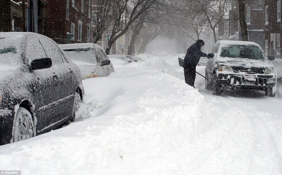
More than 300,000 homes and businesses in Michigan, upstate New York and northern New England remained without electricity Monday morning after thick ice felled trees and brought down power lines, according to utilities companies.
Brad Hoving, a meteorologist with the National Weather Service in Grand Rapids, Michigan – the state with a bulk of the remaining power outages — said many people may still be using candlelight until Thursday.
The Red Cross set up a shelter at Middleville, Michigan, United Methodist Church, but Pastor Tony Shumaker said the crowd was getting too big and needed additional accommodations like showers, so they would be moving to a local school. Church members planned to cook a Christmas dinner and bring it to the school for people who were still without power on Wednesday.

More than 300,000 homes and businesses in Midwest and northern New England remained without electricity following a major ice storm
Tony Shumaker said regardless of the inconvenient timing of lost power, the people housed at the church “seem to be in pretty decent spirits, they’re glad to have a warm place to go to”.
One of Michigan’s power providers, DTE, said crews were working “around the clock” and 90% of the 83,000 customers without electric would be restored by Christmas Eve. However, Consumers Energy said over 200,000 customers were in the dark, and many areas in the southwest portion of Michigan would not be fully restored until after the holiday.
Michigan was hit with half an inch of ice over the weekend.
The storm also saw some 1,200 US flights canceled over the weekend and delayed another 15,000, according to the aviation-tracking website FlightAware.
At least 14 deaths across the US and Canada were blamed on the storm, the AP reported.
Nine of these fatalities came in the US, including five people killed in Kentucky and a woman in Arkansas following a 130-mph tornado.
AAA predicted that a record-breaking 94.5 million Americans will travel 50 miles or more between December 21st and January 1st.
[youtube M9U2pRs7QuU 650]
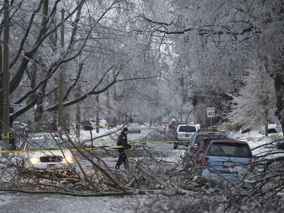
A massive ice storm has brought snow and freezing rain to Toronto, and to much of the east of Canada.
The storm has left some 400,000 people in the region without electricity and forced the closure of parts of its public transport system.
Travelers were stranded at airports in Toronto, Ottawa and Montreal as dozens of flights were cancelled or delayed.
At least 11 deaths have been blamed on the storm system in the US and Canada.
Toronto’s Mayor Rob Ford called the storm “one of the worst storms in Toronto history,” saying that a state of emergency may be called on Monday.
Rob Ford said the city’s top priority is restoring power to two hospitals, Sunnybrook and Toronto East General.
The Toronto Hydro power company said that it may take up to 72 hours to get everybody in the city reconnected.
A massive ice storm has brought snow and freezing rain to Toronto, and to much of the east of Canada
Many flights were also cancelled in the US due to the storm, at one of the busiest travel periods of the year.
More than 400,000 people were also left without power in Michigan, New York state and New England.
The US’s National Weather Service described the storm system as “complex and large”, warning that “another round of snow and ice” was expected for New England on Monday as the storm winds down.
At least four people were killed by flooding caused by the storm in Kentucky, while a tornado was reported to have caused extensive damage in Arkansas.
However, the system has also brought record high temperatures to some parts of the east coast of the US, with the temperature in New York’s Central Park reaching 21C, with records also being set in several other cities.
[youtube 2N0Xrk9Uyy8 650]
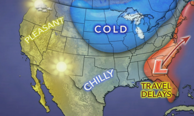
The worst weather will focus on the days prior to Christmas as millions of travelers take to the roads and skies in the US and southern Canada.
According to AAA, 94.5 million people will travel 50 miles or more over the holiday season, spanning December 21st to January 1st.
Most of the travel troubles will be caused by a single storm system forecast to affect much of the Central and Eastern states on Saturday and Sunday.
The storm this weekend will bring a wide variety of weather ranging from temperature extremes to heavy snow, ice, flooding rain, fog, severe thunderstorms and the potential for tornadoes. Major airport hubs from Dallas to St. Louis, Detroit, Atlanta, Chicago, Boston and New York City.
Another dose of snow will sweep inland over the Northwest to the northern Rockies on Monday.
The main storm this weekend will begin to put down snow across the northern Texas Panhandle and western Oklahoma on Saturday.
The worst weather will focus on the days prior to Christmas as millions of travelers take to the roads and skies in the US and southern Canada
As the storm rolls out, heavy snow will develop later Saturday over central Kansas and will continue along a northeasterly path Saturday night and Sunday through northwestern Missouri, central and southeastern Iowa and Wisconsin, much of northern Michigan and across central Ontario, southern Quebec and northern New Brunswick.
Portions of the central Plains, Upper Midwest and southeastern Canada could be on the receiving end of a foot (30 cm) of snow. Ice and a wintry mix is also another concern for travelers with the storm from part of central Oklahoma to southern Michigan, southern Ontario, along the St. Lawrence River in Ontario, northern upstate New York, northern New England central and southern New Brunswick. Enough ice can accumulate in part of this area to bring down trees and power lines.
The snow and ice could bring vehicles to a crawl or possibly shut down portions of I-29, I-35, I-70, I-80 and I-90 in the US, and highways 2, 20, 40 and 401 in Canada.
On the southeastern flank of the storm from central and coastal Texas to southern New England, drenching rain will fall. Some of the rain will be heavy enough to cause flooding.
Episodes of dense fog could also be a player in slowing ground travel and causing flight delays, especially from around the Great Lakes to the Northeast.
Farther south, there is the risk of damaging thunderstorms and tornadoes from parts of central Texas to the southern tip of Indiana Saturday and Saturday night, with the risk of locally severe thunderstorms farther east on Sunday.
A cold front associated with the storm system will push showers and thunderstorms to the Atlantic Seaboard late in the weekend. Downpours, poor visibility and locally gusty winds could cause travel delays during this time from Boston to New York City, Philadelphia, Washington, D.C., Charlotte and Atlanta Sunday afternoon and evening.
Until then, much of the area will bask in record-challenging warmth. Prior to downpours late in the weekend, fog could be a problem for a time from Philadelphia to New York City and Boston Saturday. Gusty winds could be an issue at some airports in the Northeast on Sunday.
A winter storm that started in Washington has hit Texas hard on Saturday, causing event cancellations, travel hindrances and power outages.
Almost 50 weekend holiday events had been cancelled or postponed across Texas, including Sunday’s 44th annual Dallas Marathon, which was expected to draw 25,000 runners, many of whom had trained for months. The same weather system also forced the cancellation of the St. Jude Marathon in Memphis, which had been expected to include 20,000 competitors.
Four hundred flights remained grounded Sunday at Dallas Fort Worth International airport, according to airport officials, as crews scrambled to clear airport runways.
In Chicago, people started flooding into warming centers Saturday night as wind chills dropped below zero.
Some parts of Illinois were already slammed by a foot of snow, and Chicago would get 1 to 3 inches on Sunday, according to The Weather Channel.

A winter storm has hit Texas, causing event cancellations, travel hindrances and power outages
Residents in parts of Ohio, Kentucky and Tennessee also woke up to snow and ice on Sunday.
In Virginia, state Emergency Management spokeswoman Laura Southard said the storm had the potential to be an “historic ice event.”
Other areas of the US that could expect precipitation in the form of snow or freezing rain Sunday were the Middle Missouri Valley into the Great Lakes, the Ohio and Tennessee Valleys, the Mid Atlantic and southern New England, according to the National Weather Service (NWS).
Mississippi, the Central Gulf Coast and the Tennessee Valley were all expected to dodge snowfall but could experience heavy, cold rain, the NWS predicted.
Residents in New York, Philadelphia, Washington DC, and Baltimore were warned to be careful on the roads, as they could be hit by the first major snow accumulation of the season Sunday night. But the snow is expected to change to rain overnight, the Weather Channel reported, making the morning commute a messy one.
In the even colder areas of New England and upstate New York, even a slight snowfall could create Monday morning problems as it changes to freezing rain and slippery sheets of ice, according to The Weather Channel.
The storm is expected to move out to the Atlantic on Monday night, according to the NWS.
[youtube 4gl8hmH2Lrk 650]
Winter storm Xaver hit Northern Europe claiming three lives in Poland, bringing to six the toll of people killed in hurricane-force winds.
Xaver blew a tree on to a car in Poraj, northern Poland, killing three people inside.
Most flights have been cancelled at Gdansk airport and there is serious travel disruption in Germany too.
Many schools have been closed across the north of Poland and Germany. Parts of Hamburg have been flooded.
In Poland at least 100,000 homes are without electricity because of severed power lines.
The port of Hamburg, which handles a huge amount of European trade, is at a standstill.
Hamburg has experienced its biggest tidal surges since the early 1990s. The city’s fish market and some streets by the river Elbe were flooded.
There was also limited flooding in the Netherlands – officials say the sea dykes withstood the onslaught. The Dutch and German authorities cancelled many flights and train services.
The Oeresund road-rail bridge, linking Copenhagen in Denmark with Malmo in southern Sweden, has reopened. It had been closed on Thursday evening amid high winds.
A woman died in Denmark after a lorry was blown over.
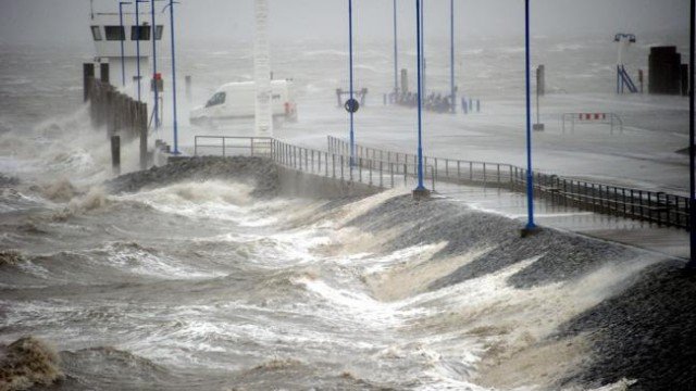
Winter storm Xaver hit Northern Europe claiming three lives in Poland, bringing to six the toll of people killed in hurricane-force winds
In Scotland a truck driver was also killed on Thursday when his vehicle was blown over near Edinburgh. A man was crushed by a falling tree in Nottinghamshire, central England.
Winds of up to 142 mph battered Scotland.
England’s east coast experienced its worst tidal surge in 60 years, while in north Wales residents had to be rescued by lifeboat crews.
Two sailors were reportedly swept overboard from a ship 14 miles off the southern Swedish coast, and air-sea rescue services failed to find them.
In the low-lying Netherlands, the Eastern Scheldt storm surge barrier was closed off for the first time in six years. Dutch authorities said they had issued the highest possible flood warning for four areas in the north and north-west of the country.
There was some flooding in Dordrecht and Rotterdam. But rail services are generally running normally in the Netherlands, the NOS news agency reports.
In Schleswig-Holstein, north Germany, many rail services have been halted. Fallen trees are littering railway lines.
The Dutch airline KLM cancelled dozens of flights from Amsterdam’s Schiphol airport on Thursday, while more than 120 were cancelled or diverted at Hamburg airport.
But Schiphol flights are now back on schedule, NOS reports.
Flights from Glasgow, Edinburgh and Aberdeen airports in Scotland were cancelled.
Rail travel was badly affected, with all train services in Scotland cancelled because of debris on the lines and damage to equipment. Services in northern England were also hit.
Ferries to Germany from Sweden and Denmark were cancelled.
[youtube AEXS56vWV5A 650]
Forecasters warned that an arctic blast will knock out power by coating parts of the South and Midwest with ice and send temperatures sinking by as much as 50 F Thursday.
The worst of the ice storm should stretch from Texas through Arkansas, the boot heel of Missouri and parts of Tennessee and Kentucky. Some places could get a half-inch or more of ice, enough to weigh down power lines and snap tree branches.
“Just prepare, plan and hunker down once this starts later tonight,” said Tom Niziol, an expert for The Weather Channel.
Kevin Roth, a lead meteorologist at the network, said that the region faced a “good 12 to 14 hours of freezing rain and ice” as an arctic air mass pushing south from Canada collides with moisture streaming up from the Gulf of Mexico.
Forecasters warned that an arctic blast will knock out power by coating parts of the South and Midwest with ice
The rough weather will be accompanied by jarring drops in the temperature. In Dallas, it was almost 80 F on Wednesday and will be in the 30s on Thursday night. In Lubbock, Texas, the high Tuesday was 77, and the forecast low for Friday night is 10.
A winter storm alert was posted for the Dallas area from 6 p.m. Thursday until 6 p.m. Friday.
Farther north and west, people faced extreme cold and snow. Temperatures could dip to minus 20 or worse in the northern midsection of the country, forecasters said. Snow totals could also approach 3 feet in northeastern Minnesota, where the weather has contributed to hundreds of traffic collisions around the state.
Colorado homeless shelters opened extra beds as temperatures in Denver were expected to drop just below zero through Friday but remain below 20 through the middle of next week. The storm dumped several inches of snow in Denver, and parts of Colorado’s mountains could get up to 3 feet by the end of the day.
Some Rocky Mountain ski resorts surpassed 100 inches of snow for the season on Wednesday.
Chicago could plunge from the mid-50s on Wednesday to the low teens by Friday night. Snow accumulations of 4 to 8 inches are possible from southern Missouri to northern Ohio through Friday night.
[youtube kTmrP026vro 650]
A wintry storm, which started in the Southwest on Thursday, could affect a good chunk of the country by the time its westward march comes to an end.
The storm making its way through New Mexico and Texas, with the possibility of advancing to the Northeast and hindering holiday travel plans along the way.
The inconveniently-timed storm will especially be a concern for the 43 million people who are expected to travel 50 miles or more for the Thanksgiving holiday, according to AAA.
Three million of those are slated to fly to their destinations, AAA predicted.
The “Nordic outbreak” will “produce a mixed bag of wily weather that will end up impacting much of the nation,” said National Weather Service meteorologist Joe Harris.
More than a foot of snow was reported on Sunday in many mountain regions of Utah and Colorado, but the greatest accumulation reached almost four feet in Abajo Peak in southeast Utah, according to the Weather Channel. Even Flagstaff, Ariz. has seen 6 inches of snow since the storm started Thursday night, according to AZ Central.
On Sunday, most of New Mexico and Texas and parts of Oklahoma were placed under National Weather Service winter storm warnings until Monday.
In New Mexico, forecasters predicted 5 inches of snow and temperatures as low as 20. The snow that began late Saturday, paired with the freezing temperatures, created dangerous driving conditions, and many roads were closed.
The icy roads there led to a rollover accident that killed a 4-year-old girl, State Police Sergeant Emmanuel Gutierrez said.

The inconveniently-timed storm will especially be a concern for the 43 million people who are expected to travel 50 miles or more for the Thanksgiving holiday
New Mexico NBC affiliate KOB reported strong winds and near white-out conditions late Saturday night along a stretch of I-40, about 80 miles west of Albuquerque.
On Saturday, a storm-related crash involving nearly a dozen vehicles left three dead in the Texas Panhandle.
Three more were killed due to the storm in California, where the storm first hit. A man was killed when he crashed his car into a tree and a woman was killed when a tree collapsed onto her parked car. A third person in California was found dead near power lines that were down due to heavy winds and flooding.
Additional flooding in Arizona swept a man into the Santa Cruz River. Firefighters recovered his body on Friday.
The wild weather system will spread east to Arkansas and northern Louisiana Sunday night into early Monday, according to the Weather Channel.
From there, it will most likely bring heavy rain to the Southeast through Tuesday, according to Weather Channel meteorologist Dr. Tom Niziol.
The storm is expected to dump rain on areas from Atlanta to the Carolinas on Monday and Tuesday then turn to snowfall over Tennessee through West Virginia as it continues to progress Northeast on Wednesday, Tom Niziol said.
Conditions in the Northeast were largely dry Sunday, but the region experienced a cold blast that bought temperatures down to 10 degrees overnight – conditions “considered cold by January standards,” according to the National Weather Service.
The region might see the second waves of the winter storm system on Wednesday, as many last minute travelers attempt to fly or drive long distances.
A blast of cold air from the north could merge with the storm system from the south and lead to snow accumulation in western and northern New England, Pennsylvania and New York, according to the Weather Channel.
In a second possibility, the two systems would not meet, but low pressure could produce snow in main northeast coastal cities.
Whether or not travelers make it to their destinations, the storm will have moved out to sea by Thanksgiving Day, allowing for dry conditions across most of the country, according to the Weather Channel.
Still, the Weather Channel predicts temperatures in the eastern part of the country will be 10 to 20 degrees below average on the holiday.
Thursday morning wind gusts between 20 and 30 mph in the Northeast could have the potential to damper the Macy’s Thanksgiving Day Parade in New York City, according to AccuWeather.com.
[youtube -lRIQOOPvRI 650]
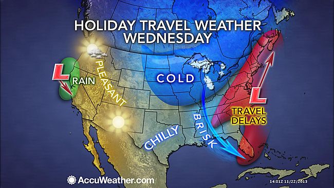
Thanksgiving travelers in the East and South on Tuesday and Wednesday will face trouble as a storm brings most areas rain but could also bring heavy snow to a narrow swath.
However, much of the rest of the nation will be dry.
The same storm affecting the Southwest with snow, ice, rain and thunderstorms this weekend will reach the Southeast with rain Tuesday. From there the storm will turn up the East Coast, tracking into colder air, perhaps causing even greater travel disruptions.
AccuWeather.com COO Evan Myers said: “If the storm hugs the coast and develops to its full potential, it could be a flight nightmare, not only for travelers in the East, but also throughout the nation.”
After drenching coastal Texas on Monday, the storm will cruise eastward along the Gulf coast Monday night and Tuesday.
Travel delays on the I-10 and I-20 corridors are in store from Louisiana to Mississippi, Alabama, Georgia and northern Florida from rain-soaked highways and poor visibility from downpours.
The rain can be heavy enough and cloud ceilings low enough to delay flights at New Orleans, Atlanta and other airports in the region.

Thanksgiving travelers in the East and South on Tuesday and Wednesday will face trouble as a storm brings most areas rain but could also bring heavy snow to a narrow swath
During Tuesday night, the drenching rain will begin to swing northeastward across South and North Carolina to Virginia, along the I-95 and I-85 corridors.
Right along the Gulf coast and over part of the southern Atlantic Seaboard, there is also the potential for strong to locally severe thunderstorms.
The exact track and intensity of the storm as it swings up or slips off the East Coast Tuesday night into Wednesday night are still in question and hold the key to dry weather versus rain versus snow in some locations.
Even if rain were to fall over much of the area, it would be enough to slow travel on the highways and delay a number of flights. Gusty winds would also factor in to delays along the coast, even if the storm were to roll out to sea.
Rain is the most likely form of precipitation from Virginia to near New York City then southeastern New England, with the air simply being too warm or the warm waters of the Atlantic Ocean exerting its influence. This includes Richmond, Virginia, Washington, D.C., Baltimore and Philadelphia.
If fresh cold air invades the storm, then there could be a period of snow over the mountains from northern West Virginia and western Maryland to central and northeastern Pennsylvania, upstate New York and western and northern New England. If this scenario pans out, major travel disruptions could be in store for portions of I-80, I-81, I-87, I-90 and I-91.
Only if the storm were to strengthen a great deal and draw more cold air in would there be a change from rain to snow in New York City, Hartford, Connecticut, and Boston.
For those traveling on Thanksgiving Day, the storm or its near-miss will likely have exited much of the region. However, some rain or snow is still possible early in the day in northern New England.
More details on the track of the storm and forecast for the Northeast will be released on AccuWeather.com as they becomes available.
A storm is forecast to move in from the Pacific Ocean during the middle of the week.
This storm will has a chance of bringing rain to the I-5 corridor in California to part of Oregon Wednesday into Thanksgiving Day.
As a result, there is a chance of wet weather and perhaps travel delays from San Francisco to Los Angeles. Some snow is possible in the Sierra Nevada and over Donner Pass along I-80.
Much of the rest of the nation will have good travel conditions.
Beware, aircraft and flight crews originating from the South and Northeast could be delayed, perhaps causing ripple-effect problems with a few flights throughout the nation.
There will be bands of lake-effect snow over the Upper Midwest, due to fresh cold air moving in Tuesday and Wednesday. The lake-effect snow should diminish in most locations by Thanksgiving Day.
[youtube -lRIQOOPvRI 650]